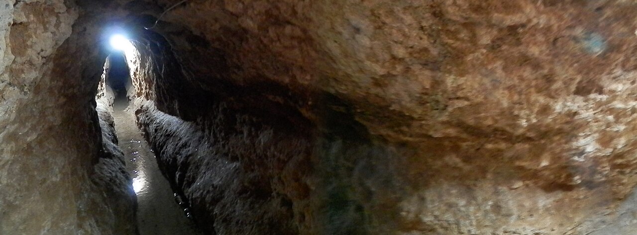

In Western Asia, water flows from the mountain to the village without a single pump, through an underground tunnel dug by hand.
Growing wheat where it does not rain is one of humanity’s oldest questions, and one of the best solved. Everywhere, societies have found ways of bringing water to where it was not. Rarely in the same way.
Water is never where you want it
The problem always arises in the same way. Water exists, but it is too far away, too low down, too scarce for part of the year and too abundant the rest of the time.
So one of these four solutions has to be used:
- Fetch it from deep down
- Bring it from far away
- Hold it back as it passes
- Stop it rushing down the slope
Each society chose according to its terrain. It is not a question of technical advance: it is a question of geography.
Fetching it from underground
In arid regions, an open canal loses an enormous amount of water: the sun evaporates it before it arrives.
The solution found in Western Asia is elegant. An underground tunnel is dug, sloping very slightly, from the foot of a mountain to the village. The water from the water table flows along it by itself, sheltered from the sun, without any pump. This is called a qanat. Ventilation shafts, lined up on the surface, are used to dig and then maintain the tunnel: seen from the sky, they draw a long line of craters.1
The same family of techniques bears different names depending on the region:
- Karez in Central Asia
- Foggara in the Sahara
- Falaj in the Arabian Peninsula
This is not an isolated invention; it is a technique that travelled.
In South Asia, the answer is different and spectacular. Rather than making the water rise, people go down to it: a monumental staircase is built, sinking into the ground. These are stepwells.
The finest of them is at Patan, in India (Rani-ki-Vav). Seven levels of stairs go down towards the water, covered with more than five hundred large sculptures. It is attributed to Queen Udayamati, who is said to have had it built in memory of her husband Bhima I, who died around 1063. This attribution does not rest on an inscription on the monument: it comes from a Jain chronicle composed two and a half centuries later, in 1304, and other dates have been proposed. It is not merely a utilitarian structure: it is built like an upside-down temple, in honour of water.2
Bringing it from far away
Elsewhere, people dig. The irrigation canals of Mesopotamia bring water from the rivers to the fields, and they have to be dredged constantly so that they do not silt up.
In China, in the third century BCE, a system was built at Dujiangyan that divides the current of a river to irrigate an entire plain — without a dam, simply by working with the shape of the riverbed. It still works today, more than two thousand two hundred years later.3
This “still today” does, however, call for a clarification. What has lasted is the idea, not the stones. Every winter, the bed is dredged, repairs are made, and what the current has carried away is rebuilt: a tax paid in grain was once used to fund this annual work. An earthquake destroyed the structure in 1933, and it was rebuilt. The centrepiece, once made of bamboo cages filled with pebbles, is now made of concrete. A structure does not last because it is solid. It lasts because it is remade. (Exactly the same thing can be found, on another continent and in another material, on the page on building: every year, the town of Djenné replasters its great mosque.)
In the Mediterranean basin, the Romans built aqueducts. We imagine them as long corridors of water set on arches — but the arches are only the visible part, about one-eighth of the route. The rest runs underground, in a masonry channel covered with a vault, precisely so that the water does not evaporate and nothing falls into it.
To dig these tunnels, the Romans did exactly what qanat diggers do: a line of vertical shafts, about every fifty metres, to bring out the spoil and then maintain the tunnel. Seen from the sky, a Persian qanat and a Roman aqueduct leave the same trace.
In Sri Lanka, yet another choice was made: holding back monsoon water in immense hand-dug reservoirs, linked to one another in a cascade, to release it during the dry season. The canals that serve them run for tens of kilometres, with a gradient so well calculated that the water carries away the mud without cutting its own bed.
One claim about these reservoirs is often repeated: Sinhalese engineers supposedly invented the sluice two thousand one hundred years ago, before anyone else. It is worth looking at where this claim comes from.
In the nineteenth century, the British, who then occupied the island, put the old reservoirs back into service. They found masonry wells in the embankments, installed sluice gates in them, and concluded that these wells had already served that purpose. Historians of science reopened the case in 2022: according to them, this conclusion rests not on what the remains show, but on the colonial engineers’ idea of the right way to distribute water.4
The reservoirs themselves are quite real, and they are remarkable. It is the explanation of exactly how they worked that is being re-examined — and it was written, it should be noted, by the occupiers of the country.
Holding it on the slope
On a hillside, water does not stay. It rushes down, and it carries the soil away with it.
The answer is the terrace: the slope is cut into steps, each held up by a wall. The Andes, the Philippines and Yemen built staircases of fields over whole mountains in this way.
The most famous are those of the Ifugao, in the Philippines. Everywhere you read that they are two thousand years old. That is not what the ground says.5
Archaeologists excavated an old village and cross-checked seventeen carbon dates with the analysis of plant remains, bones and the chemical composition of animal bones. Rice appears only from about four hundred years ago, and the terraces themselves date from the last two to four centuries. The figure of two thousand years comes from a scholar of the early twentieth century who had estimated it without any dating. It made its way into school textbooks and stayed there.6
The true story is more interesting than the legend. If the terraces date from that period, it is because they were built while the Spanish were conquering the lowlands. Growing rice in the mountains allowed the Ifugao to feed many people in the same place, to organise themselves, and to remain free. These are not the remains of a static people: they are the works of a people who reacted.7
An archaeologist who works there quotes his Ifugao colleague: “The Ifugao never said that the terraces were two thousand years old; it was the academics who said it.”
Why a false date persists
Here comes the most instructive part, and it appears in no textbook.
This correction took years to be accepted — and not only by specialists. Historians in the country went on disputing the new dates long after their publication.8
The reason is stated frankly by the researchers themselves: the tourism industry did not want it, because it saw it as a loss of prestige for the terraces.9
Two thousand years make a better selling point for visitors than four hundred.
This mechanism is found everywhere. A false date does not survive only because it has been copied. It survives because someone has an interest in its being true.
Finally, there is what the correction offers those it concerns: it does not make the Ifugao a less ancient people. It makes them a people who acted — who chose, in the face of an invasion, to transform their mountain so as to remain free there.
In Bali, the ingenuity is not only technical. The terraced rice fields are irrigated by a network in which each community of irrigators receives water in turn, according to a collectively agreed calendar. The water temples are located where the network divides, and the congregation of each temple is made up of all the farmers located below it. This system (subak) requires hundreds of people to agree, year after year.10
The proof that this system worked exists, and it is recent. In the 1970s, Balinese farmers were asked to abandon their calendar and to cultivate without interruption, with new varieties and pesticides. Harvests first rose, then collapsed: not enough water any more, and insects everywhere. Researchers then reconstructed the network on a computer to compare several ways of coordinating the calendars, from each village on its own to the whole watershed. The harvest was best at the scale of the temples.11
That is no reason, though, to turn it into a postcard. Balinese farmers still use fertilisers, and every year they lose about a thousand hectares of rice fields, sold for building — the World Heritage listing having itself attracted developers.
Making water rise
There remains one case where none of this works: when the water is below and the field is above.
- The shaduf: The simplest of remedies is a pivoting pole. A bucket at one end, a stone at the other, and the counterweight does almost all the work. A single person can raise water this way all day long.
- The noria: Cleverer still, a large wheel fitted with buckets, set in the current. It is the river that turns it. It draws water below, it pours it out above, and nobody pushes.
- The water screw (or Archimedes’ screw): A cylinder inside which a spiral partition runs: it is set on a slope, turned, and the water climbs along the axis.
Who invented the water screw?
Tradition answers Archimedes, a Greek scholar who died in 212 BCE, and ancient texts point that way. But an Oxford researcher, Stephanie Dalley, reread an inscription of the Assyrian king Sennacherib, five centuries earlier, in which he describes having had “cylinders” and “palm trees” cast in bronze. These are water screws, according to her. Other specialists object that no trace of them has been found anywhere else.12
Dalley and an archaeologist who disagreed with her, John Oleson, had a wooden water screw and the casting of a bronze screw reproduced for a television programme. Then they wrote an article together, presenting the two theses side by side.13
This is how researchers work when they do their job well: they do not hide the disagreement, they publish it.
When water damages the land
Next comes the least glorious part, and the most useful.
River water contains a little salt. When a field is irrigated under a very strong sun, the water evaporates and the salt remains. A little every year. If the land drains poorly, the salt builds up and the soil becomes barren.
This is what happened in southern Mesopotamia. Wheat, which is sensitive to salt, can be seen gradually giving way to barley, which tolerates it better. Then the harvests fall. The worst of it is that the obvious remedy makes the problem worse: watering more to rinse out the salt raises the water table and brings salt back to the surface.
One caveat, however: researchers disagree on the scale of the phenomenon. Some think it contributed heavily to the decline of the southern cities. Others stress that farmers knew of countermeasures — leaving fields to rest, draining, rinsing — and that the problem was partly brought under control. What is certain is that the mechanism exists.
It has not disappeared. Even today, vast irrigated areas around the world are becoming salinised for exactly the same reason.
Summary: five families of solutions
| Aim | Technique | Location |
|---|---|---|
| Fetch water from deep down | Underground tunnel (qanat), stepwells | Western Asia, Sahara, South Asia |
| Bring it from far away | Canals, aqueducts, river diversion | Mesopotamia, China, Mediterranean basin |
| Store it | Reservoirs linked in a cascade | Sri Lanka |
| Stop it rushing down | Terraces, regulated watering turns (subak) | Andes, Philippines, Yemen, Bali |
| Make water rise | Shaduf, noria, water screw | Egypt, Middle East, Mediterranean basin |
Note 1
Chaque qanat se compose d’un tunnel presque horizontal recueillant l’eau d’une source souterraine, habituellement un cône alluvial, dans lequel un puits mère est creusé jusqu’au niveau approprié de l’aquifère. […] Le long de tunnels souterrains, appelés koshans, l’eau est conduite par gravité, grâce à la faible pente du tunnel, jusqu’à la sortie (mazhar), […]
Each qanat consists of an almost horizontal tunnel collecting water from an underground source, usually an alluvial fan, in which a mother well is dug down to the appropriate level of the aquifer. […] Along underground tunnels, called koshans, the water is carried by gravity, thanks to the gentle slope of the tunnel, to the outlet (mazhar), […]
UNESCO, Centre du patrimoine mondial, notices “Le qanat perse” (2016), “Mont Qingcheng et système d’irrigation de Dujiangyan” (2000), “Paysage culturel de la province de Bali” (2012) et “Rani-ki-Vav à Patan” (2014)
Note 2
Conçu comme un temple inversé soulignant le caractère sacré de l’eau, il comporte sept niveaux d’escaliers et de panneaux sculptés d’une haute qualité artistique. Plus de 500 sculptures principales et un millier d’autres mineures composent une imagerie religieuse, mythologique et séculaire, avec de fréquentes références à des œuvres littéraires.
Designed as an inverted temple highlighting the sanctity of water, it has seven levels of stairs and sculpted panels of high artistic quality. More than 500 principal sculptures and a thousand minor ones make up religious, mythological and secular imagery, with frequent references to literary works.
UNESCO, Centre du patrimoine mondial, notices “Le qanat perse” (2016), “Mont Qingcheng et système d’irrigation de Dujiangyan” (2000), “Paysage culturel de la province de Bali” (2012) et “Rani-ki-Vav à Patan” (2014)
He [Bhīma] began to rule in Vikrama Saṁvata 1077, and ruled for 42 years...His queen Udayamati caused to be built in Pattana a new reservoir... […] Udayamati, therefore, in constructing the Ran-ki-Vav step well as a memorial was following a well-established tradition.
Mankodi, Kirit, “Rani ki Vav as a Commemorative Monument”, Sahapedia, online, n.d.
Besides, I flatter myself that not only students of Indian history, but folklorists and anthropologists may take interest in the quaint traditions recorded by this medieval Jain monk, which lose half their charm when paraphrased or summarized. […] Merutunga, of Vardhamanapura or Vadhvan, completed his Prabandhacintamani, according to the date given in Dinanatha's edition, in the year 1361 of the era of Vikramaditya.
Merutunga, Prabandha-Chintamani, 1304
Note 3
Modified and enlarged during the Tang, Song, Yuan and Ming dynasties, it uses natural topographic and hydrological features to solve problems of diverting water for irrigation, draining sediment, flood control, and flow control without the use of dams.
UNESCO, Centre du patrimoine mondial, notices “Le qanat perse” (2016), “Mont Qingcheng et système d’irrigation de Dujiangyan” (2000), “Paysage culturel de la province de Bali” (2012) et “Rani-ki-Vav à Patan” (2014)
Note 4
The open well structure, called bisokotuva, of the ancient sluices was interpreted as the equivalent of the modern valve pits. […] This article argues that such understanding was not based on the actual physical remains of the ancient works but was due to the colonial precept of controlled flows of irrigated water.
Jayawardana, Chandana, “Colonial Impacts on Water Supplies: An Historical Review of Sluice Technologies in Ancient Sri Lankan Irrigation”, HoST — Journal of History of Science and Technology, vol. 16, no. 1, 2022, p. 99-120
Note 5
Dominant historical narratives in the region suggest a 2000–3000 b.p. inception of the terrace systems
Acabado, Stephen B., Koller, Jared M., Liu, Chin-hsin et al., “The Short History of the Ifugao Rice Terraces: A Local Response to the Spanish Conquest”, Journal of Field Archaeology, vol. 44, no. 3, 2019, p. 195-214
Note 6
we utilize 17 radiocarbon dates, microbotanical and starch analysis, faunal isotopic signatures, and human osteological remains from the Old Kiyyangan Village site
Acabado, Stephen B., Koller, Jared M., Liu, Chin-hsin et al., “The Short History of the Ifugao Rice Terraces: A Local Response to the Spanish Conquest”, Journal of Field Archaeology, vol. 44, no. 3, 2019, p. 195-214
Note 7
the shift to wet-rice cultivation is a recent phenomenon and a response to the intrusion of the Spanish Empire in the northern highland Philippines
Acabado, Stephen B., Koller, Jared M., Liu, Chin-hsin et al., “The Short History of the Ifugao Rice Terraces: A Local Response to the Spanish Conquest”, Journal of Field Archaeology, vol. 44, no. 3, 2019, p. 195-214
Note 8
With public communication and community engagement efforts, Prof. Acabado mentioned that it took a few years – until 2014 – before Ifugao historians began accepting the idea of the young rice terraces, and as recently as 2015 there were nationalistic historians who still dispute the dates of the rice terraces.
Acabado, Stephen B. and Martin, Marlon M., présentation “Older Is Not Necessarily Better: The Short History of the Ifugao Rice Terraces”, SEAMEO SPAFA, 2020
Note 9
The tourism industry in Ifugao is also reluctant to accept the new dates because of a perceived loss in grandeur to the rice terraces.
Acabado, Stephen B. and Martin, Marlon M., présentation “Older Is Not Necessarily Better: The Short History of the Ifugao Rice Terraces”, SEAMEO SPAFA, 2020
Note 10
Each temple (which can hold 10-15 subak) meets once a year to determine planting and irrigation schedules. […] The specific timing of the crop planting cycle is based on a timing system (masa) that follows the Balinese months and accounts for the relative position of the subak compared to its up- and down-stream neighbors (e.g., higher subak plant earlier to stagger peak water requirements).
Budiyanto, Yoshi, Tellman, Beth, Vallury, Sechindra, Claborn, Kelly and Desai, Kanchi, “Balinese Subak Irrigation System”, SES Library (Social-Ecological Systems Library), Arizona State University, updated November 2025
The cultural landscape of Bali consists of five rice terraces and their water temples that cover 19,500 ha. The temples are the focus of a cooperative water management system of canals and weirs, known as subak, that dates back to the 9th century.
UNESCO, Centre du patrimoine mondial, notices “Le qanat perse” (2016), “Mont Qingcheng et système d’irrigation de Dujiangyan” (2000), “Paysage culturel de la province de Bali” (2012) et “Rani-ki-Vav à Patan” (2014)
Note 11
Anthropologist Steve Lansing and ecologist Jim Kremer built a computer model of an artificial ecosystem and showed that for different levels of coordination, from farmer level up to the level of the watershed, the temple level was the level of scale where decisions could be made to maximize the production of rice
Janssen, Marco A., “Coordination in Irrigation Systems: An Analysis of the Lansing–Kremer Model of Bali”, Agricultural Systems, vol. 93, no. 1-3, 2007, p. 170-190
Note 12
An Assyrian text from the seventh century B.C. may be interpreted to show that king Sennacherib cast such a device in bronze at Nineveh, for use in his palace garden. […] Arguments are presented for and against the invention of the device centuries before Archimedes
Dalley, Stephanie and Oleson, John Peter, “Sennacherib, Archimedes, and the Water Screw: The Context of Invention in the Ancient World”, Technology and Culture, vol. 44, no. 1, 2003, p. 1-26
Note 13
Arguments are presented for and against the invention of the device centuries before Archimedes, together with a discussion of the social context in which such inventions took place in antiquity.
Dalley, Stephanie and Oleson, John Peter, “Sennacherib, Archimedes, and the Water Screw: The Context of Invention in the Ancient World”, Technology and Culture, vol. 44, no. 1, 2003, p. 1-26
The method for casting a bronze screw implied in the Assyrian text and instructions for building a wooden water screw provided by Vitruvius were reproduced for a television program.
Dalley, Stephanie and Oleson, John Peter, “Sennacherib, Archimedes, and the Water Screw: The Context of Invention in the Ancient World”, Technology and Culture, vol. 44, no. 1, 2003, p. 1-26, paywalled
Notes and sources
- ↑
Passage An underground tunnel is dug, sloping very slightly […] The water from the water table flows along it by itself, sheltered from the sun, without any pump.
Chaque qanat se compose d’un tunnel presque horizontal recueillant l’eau d’une source souterraine, habituellement un cône alluvial, dans lequel un puits mère est creusé jusqu’au niveau approprié de l’aquifère. […] Le long de tunnels souterrains, appelés koshans, l’eau est conduite par gravité, grâce à la faible pente du tunnel, jusqu’à la sortie (mazhar), […]
Editors’ translation Each qanat consists of an almost horizontal tunnel collecting water from an underground source, usually an alluvial fan, in which a mother well is dug down to the appropriate level of the aquifer. […] Along underground tunnels, called koshans, the water is carried by gravity, thanks to the gentle slope of the tunnel, to the outlet (mazhar), […]
Source UNESCO, Centre du patrimoine mondial, notices “Le qanat perse” (2016), “Mont Qingcheng et système d’irrigation de Dujiangyan” (2000), “Paysage culturel de la province de Bali” (2012) et “Rani-ki-Vav à Patan” (2014), notice “Le qanat perse” (whc.unesco.org/fr/list/1506/), “Valeur universelle exceptionnelle”, “Brève synthèse”, 2nd paragraph.
Open access open the source · checked on 24 October 2026
- ↑
Passage Seven levels of stairs go down towards the water, covered with more than five hundred large sculptures.
Conçu comme un temple inversé soulignant le caractère sacré de l’eau, il comporte sept niveaux d’escaliers et de panneaux sculptés d’une haute qualité artistique. Plus de 500 sculptures principales et un millier d’autres mineures composent une imagerie religieuse, mythologique et séculaire, avec de fréquentes références à des œuvres littéraires.
Editors’ translation Designed as an inverted temple highlighting the sanctity of water, it has seven levels of stairs and sculpted panels of high artistic quality. More than 500 principal sculptures and a thousand minor ones make up religious, mythological and secular imagery, with frequent references to literary works.
Source UNESCO, Centre du patrimoine mondial, notices “Le qanat perse” (2016), “Mont Qingcheng et système d’irrigation de Dujiangyan” (2000), “Paysage culturel de la province de Bali” (2012) et “Rani-ki-Vav à Patan” (2014), notice for the property inscribed in 2014, description.
Open access open the source · checked on 9 September 2026
Passage It is attributed to Queen Udayamati, who is said to have had it built in memory of her husband Bhima I, who died around 1063.
He [Bhīma] began to rule in Vikrama Saṁvata 1077, and ruled for 42 years...His queen Udayamati caused to be built in Pattana a new reservoir... […] Udayamati, therefore, in constructing the Ran-ki-Vav step well as a memorial was following a well-established tradition.
Source Mankodi, Kirit, “Rani ki Vav as a Commemorative Monument”, Sahapedia, online, n.d., online article, quotations from Merutunga (Prabandhacintāmaṇi, trans. Tawney) followed by the author’s commentary; 1077 + 42 years of the Vikrama era gives 1119, i.e. about 1062-1063 CE, the end of Bhima’s reign (conversion not given in the source); the author places the monument, on stylistic grounds, in the last years of the eleventh century.
Open access open the source · checked on 27 October 2026
Passage a Jain chronicle composed two and a half centuries later, in 1304
Besides, I flatter myself that not only students of Indian history, but folklorists and anthropologists may take interest in the quaint traditions recorded by this medieval Jain monk, which lose half their charm when paraphrased or summarized. […] Merutunga, of Vardhamanapura or Vadhvan, completed his Prabandhacintamani, according to the date given in Dinanatha's edition, in the year 1361 of the era of Vikramaditya.
Source Merutunga, Prabandha-Chintamani, 1304, translator’s preface, pp. vi-vii (trans. C. H. Tawney, Calcutta, Asiatic Society, 1901); year 1361 of the Vikrama era corresponds to 1304-1305 CE (conversion not given in the source).
Public domain open the source · checked on 27 October 2026
- ↑
Passage a system was built at Dujiangyan that divides the current of a river to irrigate an entire plain — without a dam
Modified and enlarged during the Tang, Song, Yuan and Ming dynasties, it uses natural topographic and hydrological features to solve problems of diverting water for irrigation, draining sediment, flood control, and flow control without the use of dams.
Source UNESCO, Centre du patrimoine mondial, notices “Le qanat perse” (2016), “Mont Qingcheng et système d’irrigation de Dujiangyan” (2000), “Paysage culturel de la province de Bali” (2012) et “Rani-ki-Vav à Patan” (2014), notice “Mount Qingcheng and the Dujiangyan Irrigation System” (whc.unesco.org/en/list/1001/), “Outstanding Universal Value”, “Brief synthesis” (English version; the French version wrongly says “à l’aide de barrages”); same idea in the ICOMOS evaluation (September 2000, whc.unesco.org/document/151499).
Open access open the source · checked on 25 October 2026
- ↑
Passage this conclusion rests not on what the remains show, but on the colonial engineers’ idea of the right way to distribute water
The open well structure, called bisokotuva, of the ancient sluices was interpreted as the equivalent of the modern valve pits. […] This article argues that such understanding was not based on the actual physical remains of the ancient works but was due to the colonial precept of controlled flows of irrigated water.
Source Jayawardana, Chandana, “Colonial Impacts on Water Supplies: An Historical Review of Sluice Technologies in Ancient Sri Lankan Irrigation”, HoST — Journal of History of Science and Technology, vol. 16, no. 1, 2022, p. 99-120, abstract.
Open access open the source · checked on 24 October 2026
- ↑
Passage Everywhere you read that they are two thousand years old.
Dominant historical narratives in the region suggest a 2000–3000 b.p. inception of the terrace systems
Source Acabado, Stephen B., Koller, Jared M., Liu, Chin-hsin et al., “The Short History of the Ifugao Rice Terraces: A Local Response to the Spanish Conquest”, Journal of Field Archaeology, vol. 44, no. 3, 2019, p. 195-214, abstract.
Paywalled open the source · checked on 9 September 2026
- ↑
Passage Archaeologists excavated an old village and cross-checked seventeen carbon dates with the analysis of plant remains, bones and the chemical composition of animal bones.
we utilize 17 radiocarbon dates, microbotanical and starch analysis, faunal isotopic signatures, and human osteological remains from the Old Kiyyangan Village site
Source Acabado, Stephen B., Koller, Jared M., Liu, Chin-hsin et al., “The Short History of the Ifugao Rice Terraces: A Local Response to the Spanish Conquest”, Journal of Field Archaeology, vol. 44, no. 3, 2019, p. 195-214, body of the article.
Paywalled open the source · checked on 9 September 2026
- ↑
Passage it is because they were built while the Spanish were conquering the lowlands
the shift to wet-rice cultivation is a recent phenomenon and a response to the intrusion of the Spanish Empire in the northern highland Philippines
Source Acabado, Stephen B., Koller, Jared M., Liu, Chin-hsin et al., “The Short History of the Ifugao Rice Terraces: A Local Response to the Spanish Conquest”, Journal of Field Archaeology, vol. 44, no. 3, 2019, p. 195-214, abstract.
Paywalled open the source · checked on 9 September 2026
- ↑
Passage Historians in the country went on disputing the new dates long after their publication.
With public communication and community engagement efforts, Prof. Acabado mentioned that it took a few years – until 2014 – before Ifugao historians began accepting the idea of the young rice terraces, and as recently as 2015 there were nationalistic historians who still dispute the dates of the rice terraces.
Source Acabado, Stephen B. and Martin, Marlon M., présentation “Older Is Not Necessarily Better: The Short History of the Ifugao Rice Terraces”, SEAMEO SPAFA, 2020, report of the presentation (webinar of 8 July 2020).
Open access open the source · checked on 25 October 2026
- ↑
Passage the tourism industry did not want it, because it saw it as a loss of prestige for the terraces
The tourism industry in Ifugao is also reluctant to accept the new dates because of a perceived loss in grandeur to the rice terraces.
Source Acabado, Stephen B. and Martin, Marlon M., présentation “Older Is Not Necessarily Better: The Short History of the Ifugao Rice Terraces”, SEAMEO SPAFA, 2020, report of the presentation.
Open access open the source · checked on 9 September 2026
- ↑
Passage The terraced rice fields are irrigated by a network in which each community of irrigators receives water in turn, according to a collectively agreed calendar.
Each temple (which can hold 10-15 subak) meets once a year to determine planting and irrigation schedules. […] The specific timing of the crop planting cycle is based on a timing system (masa) that follows the Balinese months and accounts for the relative position of the subak compared to its up- and down-stream neighbors (e.g., higher subak plant earlier to stagger peak water requirements).
Source Budiyanto, Yoshi, Tellman, Beth, Vallury, Sechindra, Claborn, Kelly and Desai, Kanchi, “Balinese Subak Irrigation System”, SES Library (Social-Ecological Systems Library), Arizona State University, updated November 2025, § 1.4 (“Rules in Use”), aggregation rules (p. 3) and scope rules (p. 4).
Open access open the source · checked on 27 October 2026
Passage This system (subak) requires hundreds of people to agree, year after year.
The cultural landscape of Bali consists of five rice terraces and their water temples that cover 19,500 ha. The temples are the focus of a cooperative water management system of canals and weirs, known as subak, that dates back to the 9th century.
Source UNESCO, Centre du patrimoine mondial, notices “Le qanat perse” (2016), “Mont Qingcheng et système d’irrigation de Dujiangyan” (2000), “Paysage culturel de la province de Bali” (2012) et “Rani-ki-Vav à Patan” (2014), notice “Cultural Landscape of Bali Province: the Subak System as a Manifestation of the Tri Hita Karana Philosophy” (whc.unesco.org/en/list/1194/), introductory paragraph.
Open access open the source · checked on 24 October 2026
- ↑
Passage Researchers then reconstructed the network on a computer to compare several ways of coordinating the calendars, from each village on its own to the whole watershed. The harvest was best at the scale of the temples.
Anthropologist Steve Lansing and ecologist Jim Kremer built a computer model of an artificial ecosystem and showed that for different levels of coordination, from farmer level up to the level of the watershed, the temple level was the level of scale where decisions could be made to maximize the production of rice
Source Janssen, Marco A., “Coordination in Irrigation Systems: An Analysis of the Lansing–Kremer Model of Bali”, Agricultural Systems, vol. 93, no. 1-3, 2007, p. 170-190, introduction, summary of Lansing and Kremer’s result (American Anthropologist, 1993); section 2 specifies that the six levels of coordination range from a single group of 172 subaks to “each subak as a separate group”; author’s version (Digital Library of the Commons, Indiana University).
Open access (author’s version) open the source · checked on 27 October 2026
- ↑
Passage an Oxford researcher, Stephanie Dalley, reread an inscription of the Assyrian king Sennacherib […] Other specialists object
An Assyrian text from the seventh century B.C. may be interpreted to show that king Sennacherib cast such a device in bronze at Nineveh, for use in his palace garden. […] Arguments are presented for and against the invention of the device centuries before Archimedes
Source Dalley, Stephanie and Oleson, John Peter, “Sennacherib, Archimedes, and the Water Screw: The Context of Invention in the Ancient World”, Technology and Culture, vol. 44, no. 1, 2003, p. 1-26, abstract.
Paywalled open the source · checked on 25 October 2026
- ↑
Passage Dalley and an archaeologist who disagreed with her, John Oleson, […] Then they wrote an article together, presenting the two theses side by side.
Arguments are presented for and against the invention of the device centuries before Archimedes, together with a discussion of the social context in which such inventions took place in antiquity.
Source Dalley, Stephanie and Oleson, John Peter, “Sennacherib, Archimedes, and the Water Screw: The Context of Invention in the Ancient World”, Technology and Culture, vol. 44, no. 1, 2003, p. 1-26, abstract, last sentence.
Paywalled open the source · checked on 25 October 2026
Passage had a wooden water screw and the casting of a bronze screw reproduced for a television programme
The method for casting a bronze screw implied in the Assyrian text and instructions for building a wooden water screw provided by Vitruvius were reproduced for a television program.
Source Dalley, Stephanie and Oleson, John Peter, “Sennacherib, Archimedes, and the Water Screw: The Context of Invention in the Ancient World”, Technology and Culture, vol. 44, no. 1, 2003, p. 1-26, paywalled, abstract, penultimate sentence.
Paywalled open the source · checked on 27 October 2026
Bibliography
10
- Acabado, Stephen B., Koller, Jared M., Liu, Chin-hsin et al., “The Short History of the Ifugao Rice Terraces: A Local Response to the Spanish Conquest”, Journal of Field Archaeology, vol. 44, no. 3, 2019, p. 195-214, paywalled (the seventeen carbon dates cross-checked with the analysis of plants, bones and isotopes; the dominant narrative of an origin two to three thousand years old; the shift to irrigated rice farming as a response to the Spanish intrusion). https://doi.org/10.1080/00934690.2019.1574159
- Acabado, Stephen B. and Martin, Marlon M., présentation “Older Is Not Necessarily Better: The Short History of the Ifugao Rice Terraces”, SEAMEO SPAFA, 2020, open access (the years needed for the new dates to be accepted, the persistent challenges and the reluctance of the tourism industry). https://www.seameo-spafa.org/older-is-not-necessarily-better-the-short-history-of-the-ifugao-rice-terraces/
- Budiyanto, Yoshi, Tellman, Beth, Vallury, Sechindra, Claborn, Kelly and Desai, Kanchi, “Balinese Subak Irrigation System”, SES Library (Social-Ecological Systems Library), Arizona State University, updated November 2025, open access (planting and irrigation schedules set each year at the water temple, staggered according to the position of the subaks from upstream to downstream). https://seslibrary.asu.edu/sites/default/files/seslibrary/cases/balinese_subak_irrigation_system_2.pdf
- Dalley, Stephanie and Oleson, John Peter, “Sennacherib, Archimedes, and the Water Screw: The Context of Invention in the Ancient World”, Technology and Culture, vol. 44, no. 1, 2003, p. 1-26, paywalled (the two theses on the origin of the screw, set out together by two researchers who disagree). https://doi.org/10.1353/tech.2003.0011
- Janssen, Marco A., “Coordination in Irrigation Systems: An Analysis of the Lansing–Kremer Model of Bali”, Agricultural Systems, vol. 93, no. 1-3, 2007, p. 170-190, author’s version open access (Lansing and Kremer’s model re-run and tested: their finding on coordination at the scale of the temples holds, but depends on pests and on assumptions about farmers’ decisions). https://doi.org/10.1016/j.agsy.2006.05.004
- Jayawardana, Chandana, “Colonial Impacts on Water Supplies: An Historical Review of Sluice Technologies in Ancient Sri Lankan Irrigation”, HoST — Journal of History of Science and Technology, vol. 16, no. 1, 2022, p. 99-120, open access (the colonial origin of the idea of a Sinhalese invention of the sluice). https://doi.org/10.2478/host-2022-0006
- Lansing, J. Stephen, Priests and Programmers: Technologies of Power in the Engineered Landscape of Bali, Princeton University Press, 1991, in libraries (the practical role of the water temples and the collapse of harvests after the calendar was abandoned); and Lansing, J. Stephen and Kremer, James N., “Emergent Properties of Balinese Water Temple Networks”, American Anthropologist, vol. 95, no. 1, 1993, p. 97-114, paywalled (the simulation that compares several scales of coordination of the calendars and favours that of the temples).
- Mankodi, Kirit, “Rani ki Vav as a Commemorative Monument”, Sahapedia, online, n.d., open access (Merutunga’s statement on the reservoir commissioned by Udayamati, the stepwell as a commemorative monument, the stylistic dating to the late eleventh century). https://www.sahapedia.org/rani-ki-vav-commemorative-monument
- Merutunga, Prabandha-Chintamani, 1304, public domain (the mention of a “new reservoir” commissioned in Pattana by Queen Udayamati, identified with the Patan stepwell, two and a half centuries after the events).
- UNESCO, Centre du patrimoine mondial, notices “Le qanat perse” (2016), “Mont Qingcheng et système d’irrigation de Dujiangyan” (2000), “Paysage culturel de la province de Bali” (2012) et “Rani-ki-Vav à Patan” (2014), open access (the technical principles, dates and dimensions of these structures). https://whc.unesco.org/
Diagrams: generated images, checked element by element.
Spotted an error or have a doubt? Write to us.