
Peatlands cover 3 to 4% of the land surface, but store up to a third of the planet’s soil carbon.
Wetlands are also the environments that have been drained the most.
The exception
Our page on tropical forests (6.8) establishes a fact that holds for almost every environment in the world.
A forest produces oxygen and consumes roughly as much: the trees respire, and micro-organisms decompose what falls. The net balance is close to zero.
The oxygen present in the atmosphere actually comes from organic matter that, over geological time, escaped decomposition and was buried.1
And that is exactly what happens in waterlogged environments.
Under water, oxygen is almost absent. The decomposers, which need oxygen, can barely function. Plant matter accumulates instead of rotting: it forms peat, then ever deeper layers of carbon.2
These environments do not recycle everything. They accumulate. On a global scale, peatlands cover only 3 to 4% of the land surface, but they store up to one third of the world’s soil carbon — roughly twice the carbon contained in the biomass of all the world’s forests combined — the wood, not their soils. It is by trapping this carbon outside the short cycle that these environments have allowed oxygen to remain in the atmosphere.3
The vocabulary, and what it produced
The other half of this page concerns a recurring mechanism.
How were these environments named in the legal and technical texts of the eighteenth and nineteenth centuries?
Marsh. Swamp. Unhealthy land. Unproductive land.4
These words do not merely describe: they judge. “Unhealthy” decrees a threat to health. “Unproductive” decrees zero economic value.
For centuries, this terminology legitimised massive drainage policies.
This site has listed some thirty cases in which a word manufactures a belief. This one has a peculiarity: it is the first in which the word directly triggers earthworks.
In France, the law of 16 September 1807 on the drainage of marshes illustrates this shift: the legal text systematically describes these expanses as “uncultivated and unhealthy lands” in order to authorise pre-emption and finance drainage canals. The administrative watchwords did not merely plant a false idea in people’s heads: they moved millions of tonnes of earth and drained entire basins.5
The day a semicolon declassified thousands of hectares
This is a story of legal exegesis with direct ecological consequences.
To protect a wetland, regulations must first define it. Since a 2007 decree, French law has based its definition on two criteria: the morphology of the soil (hydromorphy) and the nature of the vegetation (hygrophilous plants).6
However, the syntax of the original text left room for doubt: did the two conditions have to be combined, or was one of them enough?
Three changes in three years
- In 2008, a ministerial order leans towards alternative criteria: the soil or the vegetation. One of the two is enough to classify the area.
- On 22 February 2017, the Council of State interprets the punctuation of the regulatory definition as imposing cumulative criteria (“and”). It now becomes compulsory to prove the simultaneous presence of suitable soil and vegetation.
- Immediate consequence: thousands of hectares lose their legal protection overnight, even though no physical change has taken place on the ground.
- In July 2019, the law “Establishing the French Biodiversity Office” states expressly that the criteria are alternative. The alternative character is restored.
- In June 2020, the Council of State confirms this clarification for the future.7
The reality of the decline
Beyond the legal adjustments, the physical toll remains heavy — but the figure itself has changed, and that is worth telling.
In 2018, the Ramsar Convention’s Global Wetland Outlook reported around 35% of wetlands lost since 1970. This is the figure that circulated widely for years.8
The 2025 edition gives another number for the same period: 22% since 1970, or 411 million hectares, with an ongoing decline of 0.52% per year.9
This is where the most instructive detail of this page lies.
The 35% figure has not disappeared from the report. It is still there — but with a different starting year. Since 1700, over 35% of natural wetlands have been lost.10
The point deserves emphasis: the same number, two starting dates, two different claims — and both of them accurate.
A figure for change means nothing without its starting year. The rule holds for wetlands, glaciers and forest cover alike. Any figure for change calls for an immediate check of the chosen baseline.
Someone who remembered “35%” but not the year could therefore, even today, quote a correct figure while attaching it to the wrong period. This is the mechanism of this entire page, caught in the act.
To this must be added a finding that the first figure did not provide: around a quarter of the remaining wetlands are in poor ecological condition, and this proportion is increasing in all regions. The report puts it this way: degradation now rivals outright loss.11
One last sentence conveys the scale of the problem: wetlands are disappearing faster than any other ecosystem.12
The health factor: a historical duality
This analysis would be incomplete without its medical context.
Historically, marshes were centres of transmission of malaria (or “marsh fever”), carried by Anopheles mosquitoes, as well as of other endemic diseases. In Western Europe and North America, many nineteenth-century drainage schemes responded to well-founded public-health imperatives and genuinely reduced infant mortality and endemic malaria locally.13
There are therefore two simultaneous realities:
- Wetlands were systematically disparaged through language, in pursuit of agricultural and property expansion.
- The draining of certain foci responded to a real health emergency in the face of vector-borne diseases.
Historical analysis requires establishing, case by case in the archives, which motive (economic, land-related or health-related) determined the development decision.
The physical and biological functions of coastlines
Coastal wetlands fulfil measurable roles in protection and reproduction.
Mangroves and mechanical attenuation
Mangroves — tropical coastal forests growing in saline environments — act as natural civil-engineering works. Physical oceanography measurements indicate that a band of mangrove 100 metres wide reduces the height of waves (wind and swell waves) by 13% to 66%. They retain sediment, limit erosion of the shoreline and attenuate the impact of storm surges.14
Estuarine zones and marine nurseries
Marshy coastlines, salt marshes and seagrass meadows are essential nursery areas for the ocean. A large proportion of the fish species caught worldwide — estimates range from half to three quarters depending on the region — depend on coastal or estuarine wetlands for at least one stage of their life cycle (reproduction, growth of fry, feeding).15
Technical adaptation: lake dwellings
Occupying wetlands has not always meant destroying them.
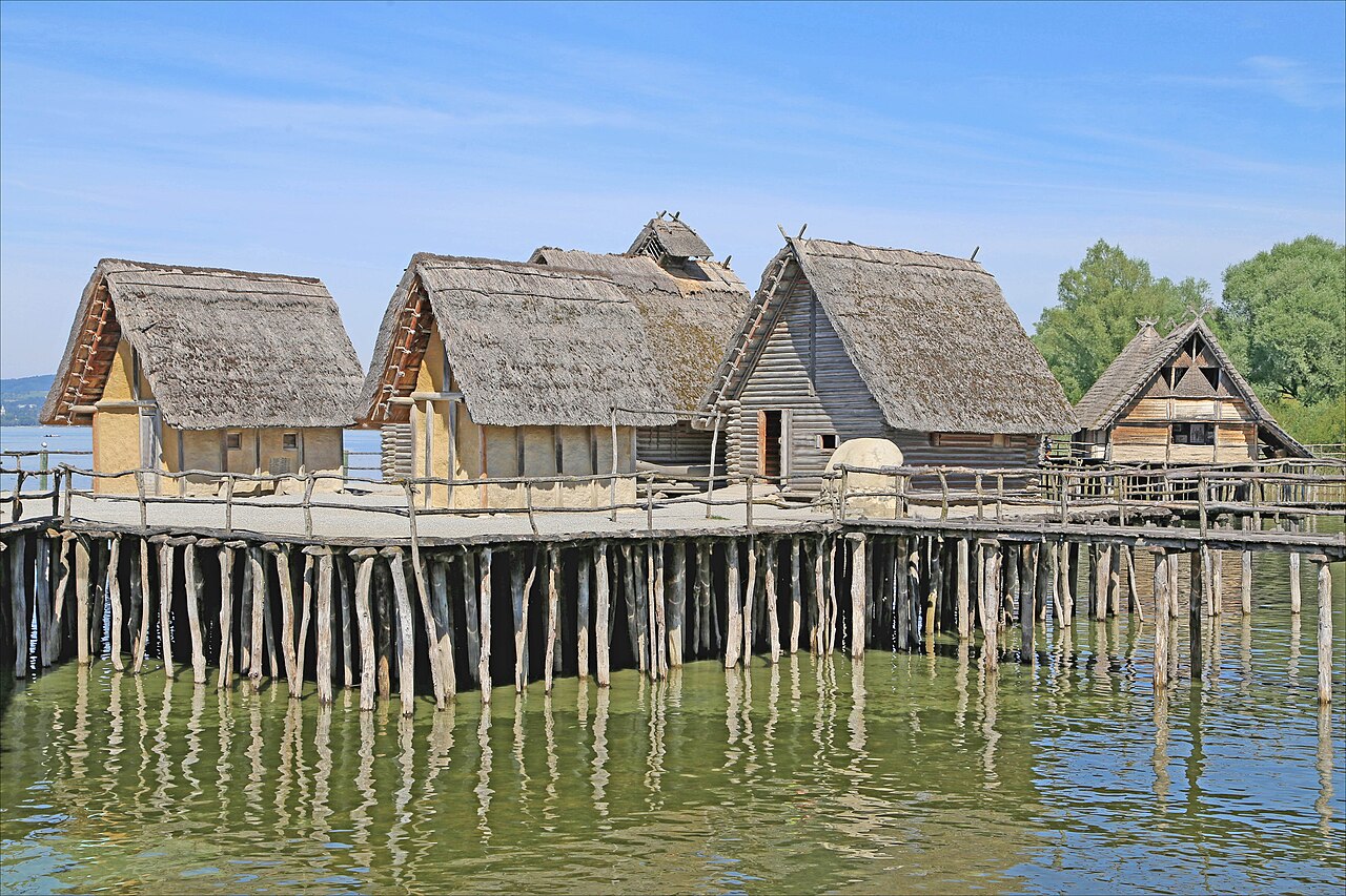
The lake city of Ganvié, in Benin, built on Lake Nokoué, is home to tens of thousands of inhabitants — around 50,000 according to a recent estimate — living in structures built on stilts. Founded by the Tofinu people, who were fleeing slave raids, in the seventeenth or eighteenth century depending on the source, this settlement shows that an aquatic environment can be suitably developed without first being drained.16
Living on the water relies on precise knowledge of the environment, the use of rot-resistant timber and a reversible construction system.
Note 1
Without burial, this oxidation reaction causes dead plant material on Earth's surface to burn. That causes the carbon it contains, which originated in the atmosphere, to bond with oxygen to form carbon dioxide. And for oxygen to build up in our atmosphere, plant organic matter must be protected from oxidation. […] Continual burial of carbon is needed to keep the atmosphere pumped up with oxygen.
Tenenbaum, David, “Fossil fuel formation: Key to atmosphere’s oxygen?”, College of Letters & Science, University of Wisconsin–Madison, 30 December 2016
Note 2
Peatlands are a wetland landscape type that is characterized by permanently waterlogged conditions, resulting in accumulation of dead plant material as peat (Gorham, 1957; Moore, 1989; Blodau, 2002).
Müller, Jurek and Joos, Fortunat, “Global Peatland Area and Carbon Dynamics from the Last Glacial Maximum to the Present – a Process-based Model Investigation”, Biogeosciences, vol. 17, no. 21, 2020, p. 5285-5308
Note 3
While they are relatively rare, covering around 3-4% of the planet’s land surface, they contain up to one third of the world’s soil carbon.
Programme des Nations unies pour l’environnement, Global Peatlands Assessment: The State of the World’s Peatlands, Nairobi, 2022
Note 4
Au milieu du xviiie siècle, l’insalubrité des zones marécageuses et des eaux stagnantes était un leitmotiv de la littérature médicale [32]. […] Le caractère peu productif de ces terres contribua aussi à la mauvaise réputation de ces espaces. […] Inutiles et nuisibles, les espaces marécageux étaient appelés à disparaître d’autant plus rapidement que la société avait besoin d’accroître sa production céréalière.
In the mid-eighteenth century, the unhealthiness of marshy areas and stagnant waters was a leitmotiv of medical literature [32]. […] The low productivity of these lands also contributed to the bad reputation of these areas. […] Useless and harmful, marshy areas were bound to disappear all the faster as society needed to increase its cereal production.
Derex, Jean-Michel, “Pour une histoire des zones humides en France (XVIIᵉ-XIXᵉ siècle). Des paysages oubliés, une histoire à écrire”, Histoire & Sociétés Rurales, no. 15, 2001, p. 11 et suiv
Note 5
L'article 33 de la loi du 16 septembre 1807 relative au dessèchement des marais prévoit que […]
Article 33 of the law of 16 September 1807 on the drainage of marshes provides that […]
Maurey, Hervé, “Nécessaire mise à jour de l’article 33 de la loi du 16 septembre 1807 relative au dessèchement des marais”, written question no. 08931, Journal officiel, Senate, 28 May 2026, p. 2554
Note 6
Un décret du 30 janvier 2007 (art. R. 211-108) retient les critères relatifs à la morphologie des sols liée à la présence prolongée d'eau d'origine naturelle et à la présence éventuelle de plantes hygrophiles.
A decree of 30 January 2007 (art. R. 211-108) adopts the criteria relating to the morphology of soils linked to the prolonged presence of water of natural origin and to the possible presence of hygrophilous plants.
Marcangelo-Leos, Philie, “Un arrêté précise les critères de définition et de délimitation des zones humides”, Localtis, Banque des Territoires, 10 July 2008
Note 7
les textes réglementaires précisant les critères retenus pour l'application de ces dispositions […] arrêté du 24 juin 2008) s'inscrivaient dans cette approche. […] validait l'aspect cumulatif de ces deux critères […] Toutefois, l'article 23 de la loi n°2019-773 du 24 juillet 2019 portant création de l'office français de la biodiversité a modifié les dispositions du 1° du I de l'article L. 211-1 du code de l'environnement […] précisant expressément le caractère alternatif des critères physiques et biologiques précités
the regulatory texts specifying the criteria adopted for the application of these provisions […] order of 24 June 2008) were in line with this approach. […] upheld the cumulative aspect of these two criteria […] However, Article 23 of Law no. 2019-773 of 24 July 2019 establishing the French Biodiversity Office amended the provisions of point 1° of section I of Article L. 211-1 of the Environment Code […] expressly specifying the alternative character of the aforementioned physical and biological criteria
DREAL Auvergne-Rhône-Alpes, Mission juridique, “Identification d’une zone humide : des critères “alternatifs” l’un physique, l’autre biologique”, fiche 3851-FJ-2017, mise à jour le 9 March 2021, open access
Note 8
wetlands are declining fast, with 35% losses since 1970, where data are available.
Convention de Ramsar sur les zones humides, Global Wetland Outlook: State of the World’s Wetlands and their Services to People, résumé, Gland, Secrétariat de la Convention de Ramsar, 2018, open access
Note 9
Since 1970, an estimated 411 million hectares of wetlands — approximately 22% of the global total — have been lost, with an ongoing annual decline of 0.52%.
Convention sur les zones humides (Ramsar), Global Wetland Outlook 2025: Valuing, Conserving, Restoring and Financing Wetlands, site officiel du rapport, 2025, open access
Note 10
Despite this, the Outlook confirms that since 1700, over 35% of natural wetlands have been lost worldwide, and the trend shows no sign of slowing.
Noor, Yus Rusila (Wetlands International Indonesia), “The Global Wetland Outlook 2025: A Critical Appraisal of Valuing, Conserving, Restoring, and Financing Wetlands”, 22 July 2025, open access
Note 11
Around 25% of the remaining wetlands are in poor ecological condition, and this proportion is increasing in all regions.
Convention sur les zones humides (Ramsar), Global Wetland Outlook 2025: Valuing, Conserving, Restoring and Financing Wetlands, site officiel du rapport, 2025, open access
Degradation now rivals outright loss.
Convention sur les zones humides (Ramsar), Global Wetland Outlook 2025: Valuing, Conserving, Restoring and Financing Wetlands, site officiel du rapport, 2025, open access
Note 12
Wetlands, which sustain life across the planet, are disappearing faster than any other ecosystem.
Convention sur les zones humides (Ramsar), communiqué de presse sur le Global Wetland Outlook 2025, Nairobi, 15 July 2025, open access
Note 13
In this report we analyze temporal trends in malaria in Britain between 1840 and 1910, to assess the potential for reemergence of the disease. Our results demonstrate that at least 20% of the drop-off in malaria was due to increasing cattle population and decreasing acreage of marsh wetlands.
Kuhn, Katrin G. et al., “Malaria in Britain: Past, Present, and Future”, Proceedings of the National Academy of Sciences, vol. 100, 2003, p. 9997-10001
Note 14
All evidence suggests that mangroves can reduce the height of wind and swell waves over relatively short distances: wave height can be reduced by between 13 and 66% over 100 m of mangroves.
McIvor, Anna L., Möller, Iris, Spencer, Tom and Spalding, Mark, Reduction of Wind and Swell Waves by Mangroves, The Nature Conservancy et Wetlands International, 2012
Note 15
Two thirds of all fish consumed are dependent on coastal wetlands at some stage in their life cycle, a globally important function that far surpasses the actual area covered by these wetlands.
Ramsar Convention Bureau, “Wetland Products”, Wetland Values and Functions series, Gland, n. d.
Note 16
Perchée sur pilotis au bord du lac Nokoué, la cité lacustre de Ganvié est l’une des perles du Bénin. […] cette cité d’apparence fragile servait au XVIIIe siècle de refuge aux rescapés des razzias esclavagistes.
Perched on stilts on the shore of Lake Nokoué, the lake city of Ganvié is one of the jewels of Benin. […] this fragile-looking city served in the eighteenth century as a refuge for survivors of the slave raids.
Agence française de développement, “Ganvié : accompagner la remise à flot de la Venise africaine”
Fuyant les guerres intertribales et les razzias esclavagistes des royaumes d'Abomey et d'Oyo au XVIIè siècle, les Toffinous qui en sont les premiers habitants, se seraient installés dans un premier temps sur le plateau d'Allada
Fleeing the inter-tribal wars and the slave raids of the kingdoms of Abomey and Oyo in the seventeenth century, the Tofinu, who were its first inhabitants, are said to have settled first on the Allada plateau
Government of the Republic of Benin, “Destination Bénin : Sô-Ava, cité pittoresque, au cœur de l’art de la vie sur l’eau”, 14 January 2021
Elle abrite aujourd’hui environ 50 000 habitants.
It is now home to around 50,000 inhabitants.
Agence française de développement, “Ganvié : accompagner la remise à flot de la Venise africaine”
Notes and sources
- ↑
Passage The oxygen present in the atmosphere actually comes from organic matter that, over geological time, escaped decomposition and was buried
Without burial, this oxidation reaction causes dead plant material on Earth's surface to burn. That causes the carbon it contains, which originated in the atmosphere, to bond with oxygen to form carbon dioxide. And for oxygen to build up in our atmosphere, plant organic matter must be protected from oxidation. […] Continual burial of carbon is needed to keep the atmosphere pumped up with oxygen.
Source Tenenbaum, David, “Fossil fuel formation: Key to atmosphere’s oxygen?”, College of Letters & Science, University of Wisconsin–Madison, 30 December 2016, body of the article, 7th and 19th paragraphs.
Open access open the source · checked on 27 October 2026
- ↑
Passage Plant matter accumulates instead of rotting: it forms peat
Peatlands are a wetland landscape type that is characterized by permanently waterlogged conditions, resulting in accumulation of dead plant material as peat (Gorham, 1957; Moore, 1989; Blodau, 2002).
Source Müller, Jurek and Joos, Fortunat, “Global Peatland Area and Carbon Dynamics from the Last Glacial Maximum to the Present – a Process-based Model Investigation”, Biogeosciences, vol. 17, no. 21, 2020, p. 5285-5308, section 1 “Introduction”, 1st paragraph, 1st sentence.
Open access open the source · checked on 9 September 2026
- ↑
Passage peatlands cover only 3 to 4% of the land surface, but they store up to one third of the world’s soil carbon
While they are relatively rare, covering around 3-4% of the planet’s land surface, they contain up to one third of the world’s soil carbon.
Source Programme des Nations unies pour l’environnement, Global Peatlands Assessment: The State of the World’s Peatlands, Nairobi, 2022, Summary for Policy Makers, “Policy Summary”, p. 2.
Open access open the source · checked on 24 October 2026
- ↑
Passage Marsh. Swamp. Unhealthy land. Unproductive land. […] this terminology legitimised massive drainage policies
Au milieu du xviiie siècle, l’insalubrité des zones marécageuses et des eaux stagnantes était un leitmotiv de la littérature médicale [32]. […] Le caractère peu productif de ces terres contribua aussi à la mauvaise réputation de ces espaces. […] Inutiles et nuisibles, les espaces marécageux étaient appelés à disparaître d’autant plus rapidement que la société avait besoin d’accroître sa production céréalière.
Editors’ translation In the mid-eighteenth century, the unhealthiness of marshy areas and stagnant waters was a leitmotiv of medical literature [32]. […] The low productivity of these lands also contributed to the bad reputation of these areas. […] Useless and harmful, marshy areas were bound to disappear all the faster as society needed to increase its cereal production.
Source Derex, Jean-Michel, “Pour une histoire des zones humides en France (XVIIᵉ-XIXᵉ siècle). Des paysages oubliés, une histoire à écrire”, Histoire & Sociétés Rurales, no. 15, 2001, p. 11 et suiv, § 17, § 21 (1st sentence) and § 22 (1st sentence) of the online text.
Open access open the source · checked on 27 October 2026
- ↑
Passage the law of 16 September 1807 on the drainage of marshes
L'article 33 de la loi du 16 septembre 1807 relative au dessèchement des marais prévoit que […]
Editors’ translation Article 33 of the law of 16 September 1807 on the drainage of marshes provides that […]
Source Maurey, Hervé, “Nécessaire mise à jour de l’article 33 de la loi du 16 septembre 1807 relative au dessèchement des marais”, written question no. 08931, Journal officiel, Senate, 28 May 2026, p. 2554, text of the question, first sentence after the introduction; title of the question.
Open access open the source · checked on 27 October 2026
- ↑
Passage Since a 2007 decree, French law has based its definition on two criteria: the morphology of the soil (hydromorphy) and the nature of the vegetation (hygrophilous plants).
Un décret du 30 janvier 2007 (art. R. 211-108) retient les critères relatifs à la morphologie des sols liée à la présence prolongée d'eau d'origine naturelle et à la présence éventuelle de plantes hygrophiles.
Editors’ translation A decree of 30 January 2007 (art. R. 211-108) adopts the criteria relating to the morphology of soils linked to the prolonged presence of water of natural origin and to the possible presence of hygrophilous plants.
Source Marcangelo-Leos, Philie, “Un arrêté précise les critères de définition et de délimitation des zones humides”, Localtis, Banque des Territoires, 10 July 2008, body of the article, 5th paragraph.
Open access open the source · checked on 27 October 2026
- ↑
Passage In 2008, a ministerial order leans towards alternative criteria […] On 22 February 2017, the Council of State interprets […] cumulative […] In July 2019, the law […] states expressly that the criteria are alternative
les textes réglementaires précisant les critères retenus pour l'application de ces dispositions […] arrêté du 24 juin 2008) s'inscrivaient dans cette approche. […] validait l'aspect cumulatif de ces deux critères […] Toutefois, l'article 23 de la loi n°2019-773 du 24 juillet 2019 portant création de l'office français de la biodiversité a modifié les dispositions du 1° du I de l'article L. 211-1 du code de l'environnement […] précisant expressément le caractère alternatif des critères physiques et biologiques précités
Editors’ translation the regulatory texts specifying the criteria adopted for the application of these provisions […] order of 24 June 2008) were in line with this approach. […] upheld the cumulative aspect of these two criteria […] However, Article 23 of Law no. 2019-773 of 24 July 2019 establishing the French Biodiversity Office amended the provisions of point 1° of section I of Article L. 211-1 of the Environment Code […] expressly specifying the alternative character of the aforementioned physical and biological criteria
Source DREAL Auvergne-Rhône-Alpes, Mission juridique, “Identification d’une zone humide : des critères “alternatifs” l’un physique, l’autre biologique”, fiche 3851-FJ-2017, mise à jour le 9 March 2021, open access, DREAL legal fact sheet, history of the definition (2008 order, Council of State 22 February 2017, 2019 law, Council of State 17 June 2020).
Open access open the source · checked on 24 October 2026
- ↑
Passage In 2018 […] around 35% of wetlands lost since 1970
wetlands are declining fast, with 35% losses since 1970, where data are available.
Source Convention de Ramsar sur les zones humides, Global Wetland Outlook: State of the World’s Wetlands and their Services to People, résumé, Gland, Secrétariat de la Convention de Ramsar, 2018, open access, 2018 summary, p. 2, “Key Messages”.
Open access open the source · checked on 24 October 2026
- ↑
Passage 22% since 1970, or 411 million hectares, with an ongoing decline of 0.52% per year
Since 1970, an estimated 411 million hectares of wetlands — approximately 22% of the global total — have been lost, with an ongoing annual decline of 0.52%.
Source Convention sur les zones humides (Ramsar), Global Wetland Outlook 2025: Valuing, Conserving, Restoring and Financing Wetlands, site officiel du rapport, 2025, open access, home page of the Global Wetland Outlook 2025 website.
Open access open the source · checked on 24 October 2026
- ↑
Passage Since 1700, over 35% of natural wetlands have been lost.
Despite this, the Outlook confirms that since 1700, over 35% of natural wetlands have been lost worldwide, and the trend shows no sign of slowing.
Source Noor, Yus Rusila (Wetlands International Indonesia), “The Global Wetland Outlook 2025: A Critical Appraisal of Valuing, Conserving, Restoring, and Financing Wetlands”, 22 July 2025, open access, Wetlands International Indonesia article, 22 July 2025.
Open access open the source · checked on 24 October 2026
- ↑
Passage around a quarter of the remaining wetlands are in poor ecological condition, and this proportion is increasing in all regions
Around 25% of the remaining wetlands are in poor ecological condition, and this proportion is increasing in all regions.
Source Convention sur les zones humides (Ramsar), Global Wetland Outlook 2025: Valuing, Conserving, Restoring and Financing Wetlands, site officiel du rapport, 2025, open access, home page of the Global Wetland Outlook 2025 website.
Open access open the source · checked on 24 October 2026
Passage degradation now rivals outright loss
Degradation now rivals outright loss.
Source Convention sur les zones humides (Ramsar), Global Wetland Outlook 2025: Valuing, Conserving, Restoring and Financing Wetlands, site officiel du rapport, 2025, open access, home page of the Global Wetland Outlook 2025 website.
Open access open the source · checked on 24 October 2026
- ↑
Passage wetlands are disappearing faster than any other ecosystem
Wetlands, which sustain life across the planet, are disappearing faster than any other ecosystem.
Source Convention sur les zones humides (Ramsar), communiqué de presse sur le Global Wetland Outlook 2025, Nairobi, 15 July 2025, open access, press release of 15 July 2025, first paragraph.
Open access open the source · checked on 24 October 2026
- ↑
Passage marshes were centres of transmission of malaria […] many nineteenth-century drainage schemes […] genuinely reduced […] endemic malaria locally
In this report we analyze temporal trends in malaria in Britain between 1840 and 1910, to assess the potential for reemergence of the disease. Our results demonstrate that at least 20% of the drop-off in malaria was due to increasing cattle population and decreasing acreage of marsh wetlands.
Source Kuhn, Katrin G. et al., “Malaria in Britain: Past, Present, and Future”, Proceedings of the National Academy of Sciences, vol. 100, 2003, p. 9997-10001, abstract, 2nd and 3rd sentences.
Open access · checked on 9 September 2026
- ↑
Passage a band of mangrove 100 metres wide reduces the height of waves (wind and swell waves) by 13% to 66%
All evidence suggests that mangroves can reduce the height of wind and swell waves over relatively short distances: wave height can be reduced by between 13 and 66% over 100 m of mangroves.
Source McIvor, Anna L., Möller, Iris, Spencer, Tom and Spalding, Mark, Reduction of Wind and Swell Waves by Mangroves, The Nature Conservancy et Wetlands International, 2012, Executive Summary, p. 3.
Open access · checked on 24 October 2026
- ↑
Passage A large proportion of the fish species caught worldwide […] depend on coastal or estuarine wetlands
Two thirds of all fish consumed are dependent on coastal wetlands at some stage in their life cycle, a globally important function that far surpasses the actual area covered by these wetlands.
Source Ramsar Convention Bureau, “Wetland Products”, Wetland Values and Functions series, Gland, n. d., “Wetland Products” sheet, main text (paragraph on fisheries).
Open access open the source · checked on 27 October 2026
- ↑
Passage The lake city of Ganvié, in Benin, built on Lake Nokoué […] Founded by the Tofinu people, who were fleeing slave raids, in the seventeenth or eighteenth century depending on the source
Perchée sur pilotis au bord du lac Nokoué, la cité lacustre de Ganvié est l’une des perles du Bénin. […] cette cité d’apparence fragile servait au XVIIIe siècle de refuge aux rescapés des razzias esclavagistes.
Editors’ translation Perched on stilts on the shore of Lake Nokoué, the lake city of Ganvié is one of the jewels of Benin. […] this fragile-looking city served in the eighteenth century as a refuge for survivors of the slave raids.
Source Agence française de développement, “Ganvié : accompagner la remise à flot de la Venise africaine”, body of the article (18 April 2023).
Open access open the source · checked on 27 October 2026
Passage Founded by the Tofinu people, who were fleeing slave raids, in the seventeenth or eighteenth century depending on the source
Fuyant les guerres intertribales et les razzias esclavagistes des royaumes d'Abomey et d'Oyo au XVIIè siècle, les Toffinous qui en sont les premiers habitants, se seraient installés dans un premier temps sur le plateau d'Allada
Editors’ translation Fleeing the inter-tribal wars and the slave raids of the kingdoms of Abomey and Oyo in the seventeenth century, the Tofinu, who were its first inhabitants, are said to have settled first on the Allada plateau
Source Government of the Republic of Benin, “Destination Bénin : Sô-Ava, cité pittoresque, au cœur de l’art de la vie sur l’eau”, 14 January 2021, paragraph on the origins of settlement in the commune of Sô-Ava (Ganvié I and II districts).
Open access open the source · checked on 27 October 2026
Passage The lake city of Ganvié […] is home to tens of thousands of inhabitants — around 50,000 according to a recent estimate
Elle abrite aujourd’hui environ 50 000 habitants.
Editors’ translation It is now home to around 50,000 inhabitants.
Source Agence française de développement, “Ganvié : accompagner la remise à flot de la Venise africaine”, presentation of the renovation project (18 April 2023).
Open access open the source · checked on 9 September 2026
Bibliography
23
- Agence française de développement, “Ganvié : accompagner la remise à flot de la Venise africaine”, open access (the renovation programme under way since 2019, a population estimated at around 50,000 inhabitants, and its role as a refuge from slave raids in the eighteenth century). https://www.afd.fr/fr/actualites/ganvie-accompagner-la-remise-flot-de-la-venise-africaine
- Barbier, Edward B. et al., “The Value of Estuarine and Coastal Ecosystem Services”, Ecological Monographs, vol. 81, 2011, p. 169-193, paywalled (coastal nurseries and the share of fisheries that depend on them).
- Barnaud, Geneviève and Fustec, Éliane, Conserver les milieux humides : pourquoi ? comment ?, Éducagri éditions et Éditions Quæ, 2007, in libraries (the soil and vegetation criteria and their application).
- Berner, Robert A., “The Long-term Carbon Cycle, Fossil Fuels and Atmospheric Composition”, Nature, vol. 426, 2003, p. 323-326, paywalled (atmospheric oxygen and carbon burial; see entry 6.8).
- Bourgoignie, Georges E., Les Hommes de l’eau. Ethno-écologie du Dahomey lacustre, Éditions universitaires, 1972, in libraries (Ganvié; see entry 2.5).
- Convention de Ramsar sur les zones humides, Global Wetland Outlook: State of the World’s Wetlands and their Services to People, résumé, Gland, Secrétariat de la Convention de Ramsar, 2018, open access (around 35% losses since 1970, where data exist). https://ramsar.org/sites/default/files/documents/library/gwo_summary_e.pdf
- Convention sur les zones humides (Ramsar), Global Wetland Outlook 2025: Valuing, Conserving, Restoring and Financing Wetlands, site officiel du rapport, 2025, open access (411 million hectares and around 22% since 1970; 0.52% per year; around 25% of the remaining areas in poor condition, a proportion increasing in all regions; degradation rivalling outright loss). https://www.global-wetland-outlook.ramsar.org/
- Convention sur les zones humides (Ramsar), communiqué de presse sur le Global Wetland Outlook 2025, Nairobi, 15 July 2025, open access (wetlands are disappearing faster than any other ecosystem). https://www.global-wetland-outlook.ramsar.org/s/GWO-Press-Release-ENG-rr95.pdf
- Davidson, Nick C., “How Much Wetland Has the World Lost? Long-term and Recent Trends in Global Wetland Area”, Marine and Freshwater Research, vol. 65, 2014, p. 934-941, paywalled (losses depending on the reference year chosen).
- Derex, Jean-Michel, “Pour une histoire des zones humides en France (XVIIᵉ-XIXᵉ siècle). Des paysages oubliés, une histoire à écrire”, Histoire & Sociétés Rurales, no. 15, 2001, p. 11 et suiv., open access (the vocabulary of unhealthiness and drainage policies). https://shs.cairn.info/revue-histoire-et-societes-rurales-2001-1-page-11?lang=fr
- DREAL Auvergne-Rhône-Alpes, Mission juridique, “Identification d’une zone humide : des critères “alternatifs” l’un physique, l’autre biologique”, fiche 3851-FJ-2017, mise à jour le 9 March 2021, open access (the history: the 2008 texts in the alternative approach, the 2017 ruling with cumulative criteria, “or” restored by Article 23 of the 2019 law, the decision of 17 June 2020). https://www.auvergne-rhone-alpes.developpement-durable.gouv.fr/IMG/pdf/3851-fj-2017maj.pdf
- Government of the Republic of Benin, “Destination Bénin : Sô-Ava, cité pittoresque, au cœur de l’art de la vie sur l’eau”, 14 January 2021, open access (the Tofinu, the first inhabitants of the commune of Sô-Ava, fleeing the slave raids of Abomey and Oyo in the seventeenth century). https://www.gouv.bj/article/1130/destination-benin-cite-pittoresque-coeur-eau/
- Kuhn, Katrin G. et al., “Malaria in Britain: Past, Present, and Future”, Proceedings of the National Academy of Sciences, vol. 100, 2003, p. 9997-10001, open access (the draining of marshes and the decline of malaria in Europe).
- Loi du 16 September 1807 relative au dessèchement des marais, Bulletin des lois, 1807, public domain (the imperial legal framework and its vocabulary).
- Marcangelo-Leos, Philie, “Un arrêté précise les critères de définition et de délimitation des zones humides”, Localtis, Banque des Territoires, 10 July 2008, open access (the two criteria of the 2007 decree and the 2008 order: soil morphology and hygrophilous plants). https://www.banquedesterritoires.fr/un-arrete-precise-les-criteres-de-definition-et-de-delimitation-des-zones-humides
- Maurey, Hervé, “Nécessaire mise à jour de l’article 33 de la loi du 16 septembre 1807 relative au dessèchement des marais”, written question no. 08931, Journal officiel, Senate, 28 May 2026, p. 2554, open access (the exact title of the law, whose Article 33 is still in force). https://www.senat.fr/questions/base/2026/qSEQ260508931.html
- McIvor, Anna L., Möller, Iris, Spencer, Tom and Spalding, Mark, Reduction of Wind and Swell Waves by Mangroves, The Nature Conservancy et Wetlands International, 2012, open access (13 to 66% attenuation over a width of 100 metres).
- Müller, Jurek and Joos, Fortunat, “Global Peatland Area and Carbon Dynamics from the Last Glacial Maximum to the Present – a Process-based Model Investigation”, Biogeosciences, vol. 17, no. 21, 2020, p. 5285-5308, open access (in permanently waterlogged peatlands, dead plant matter accumulates as peat). https://bg.copernicus.org/articles/17/5285/2020/
- Noor, Yus Rusila (Wetlands International Indonesia), “The Global Wetland Outlook 2025: A Critical Appraisal of Valuing, Conserving, Restoring, and Financing Wetlands”, 22 July 2025, open access (the report confirms that over 35% of natural wetlands have been lost since 1700 — a reading by a conservation organisation, as the full report could not be consulted). https://indonesia.wetlands.org/blog/the-global-wetland-outlook-2025-a-critical-appraisal-of-valuing-conserving-restoring-and-financing-wetlands/
- Programme des Nations unies pour l’environnement, Global Peatlands Assessment: The State of the World’s Peatlands, Nairobi, 2022, open access (3% of the land surface, around 30% of soil carbon).
- Ramsar Convention Bureau, “Wetland Products”, Wetland Values and Functions series, Gland, n. d., open access (two thirds of all fish consumed depend on coastal wetlands at some stage in their life cycle). https://www.ramsar.org/sites/default/files/documents/tmp/pdf/info/values_products_e.pdf
- Tenenbaum, David, “Fossil fuel formation: Key to atmosphere’s oxygen?”, College of Letters & Science, University of Wisconsin–Madison, 30 December 2016, open access (the work of Shanan Peters and Jon Husson: oxygen builds up in the atmosphere only if buried organic matter escapes oxidation). https://ls.wisc.edu/news/fossil-fuel-formation-key-to-atmospheres-oxygen
- Yu, Zicheng et al., “Global Peatland Dynamics since the Last Glacial Maximum”, Geophysical Research Letters, vol. 37, L13402, 2010, open access.
Spotted an error or have a doubt? Write to us.