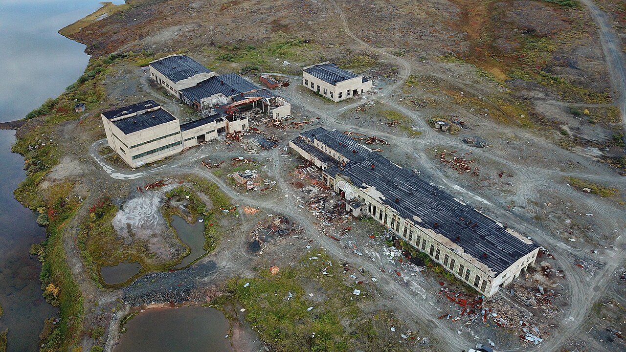

The deepest hole ever dug by humankind goes down twelve kilometres. That is about two thousandths of the distance to the centre of the Earth.
Nobody has ever gone down to look. This page tells how we know nonetheless.
The hole
Drilling began in 1970 on the Kola Peninsula, in north-western Russia. It reached 12,262 metres in 1989.1
The main hole is only about twenty-three centimetres wide. Twenty years of work for a tube as wide as a plate.2
It did not reach its target, which was fifteen kilometres.
Why it stopped
Three reasons, and they are of different kinds:
- The heat. Going down, the temperature rose faster than the model predicted. At the bottom, 180 °C was recorded where about 100 had been expected.
- The rock. At that temperature, the rock changed its behaviour: having become plastic, it closed back in on itself and destroyed the equipment.
- The money. The Soviet Union broke up, and the funding disappeared with it. Work stopped in 1992; the site was sealed in 1995.3
The figure that counts
Twelve kilometres seems a lot. It is deeper than the deepest ocean trench.
But set against the Earth: 12,262 metres is about 0.2% of the distance to the centre. Only a third of the thickness of the crust at that spot.
The greatest drilling effort in human history did not even get through the first layer.
The layers of the Earth
The Earth is not a solid, uniform ball. It is made of nested layers, ever hotter and denser the deeper one goes. At the centre, the temperature approaches that of the surface of the Sun and the pressure exceeds three million times the pressure we experience in the open air.
- The crust is the surface layer, the one on which we live. It ranges from 5 kilometres thick beneath the oceans to 70 kilometres beneath the great mountain ranges. Compared with the whole Earth, that is less than a hundredth of the radius.
- The mantle occupies most of the volume — about 84%. It extends down to about 2,900 kilometres. It is almost entirely solid, despite what one often reads: it is not an ocean of lava. It is just that, over very long periods, this solid rock creeps very slowly, like an extremely stiff paste.
- The outer core, between 2,900 and 5,100 kilometres, is made of liquid iron and nickel. Its movements generate the Earth’s magnetic field.
- The inner core is a sphere of iron with a radius of about 1,200 kilometres. It is hotter than the outer core and yet solid: the pressure there is such that the iron cannot remain liquid.4
None of these layers has ever been seen. The deepest borehole ever drilled stops at a little over twelve kilometres — it did not even get through the crust. Everything described above was established by other means, and that is the subject of this page.
How we see inside the Earth
We have never seen the inside of the Earth. Yet we know its layered structure.
The principle
When an earthquake occurs, it sends vibrations (seismic waves) in all directions, including through the planet. These waves do not travel in the same way depending on the matter they pass through: they change speed, bend, or stop dead.
By placing sensors over the whole surface and comparing arrival times, the path travelled is reconstructed. From these paths, one deduces what lies along the way.
The most elegant discovery
There are two main types of deep seismic waves:
- P waves (primary), which pass through solids and liquids alike.
- S waves (secondary), which do not pass through liquids.
Now, after a major earthquake, a vast region on the opposite side of the globe is found never to receive S waves. It is called the shadow zone.
The conclusion is inescapable: something liquid blocks their passage at the centre. This is how it was discovered that the outer core is liquid — not by seeing it, but by noting the absence of something. In 1926, Harold Jeffreys provided the first quantitative demonstration, by combining this absence of S waves with the amplitude of Earth tides: the Earth deforms too much to be rigid all the way to its centre.5
The lesson of method
It is a fundamental epistemological principle: an absence can be information. What does not arrive, where it ought to arrive, tells us about what lies in between.
The reversal is striking: our knowledge of the subsurface rests on disasters. The phenomenon that destroys cities is also the only scanner that lets us see beneath our feet. We did not build it: we make use of it.
What the drilling contradicted
The main scientific result from Kola is something it did not find.
Seismologists had long observed that waves abruptly change speed at about seven kilometres depth beneath the continents. They saw in this a boundary between a granite crust and a denser basalt crust — the “Conrad Discontinuity”. That was the main target of the drilling.6
The drill went down to check. There was no basalt. Granite above, and more rock of the same kind below.7
An instrument lowered on the spot contradicted the reading of a signal listened to from above. The measurement was not wrong; it was the sentence written over it that was wrong.
Three surprises nobody had ordered
Instead, the drilling found something else — and that is often how it goes.
- Water. Salt water was circulating in cracks, several kilometres down, where nobody expected to find any. That is what explains the change in wave speed: not a different rock, but the same rock, fractured and saturated with water.
- Gas. Throughout the drilling, hydrogen bubbled up from the well.
- Fossils. At about six kilometres depth, in rock about two billion years old, microscopic remains of plankton were found.8
The familiar layered diagram — crust, mantle, core, like an onion cut in half — is a model. A tool for reasoning, not a photograph.
A fact too good to be true, named as such
A legend has been circulating since the late twentieth century: human screams were supposedly heard at the bottom of the Kola borehole, recorded by a heat-resistant microphone.
It is a documented hoax. Its trail can even be followed: a religious television channel in California broadcast it, after a Finnish Christian newsletter had published it in July 1989. A radio host, harassed by calls from listeners who wanted to know whether it was true, traced it back to that newsletter.9
What makes the case exemplary: the scientific publications on the borehole do describe startling facts: fractured rocks saturated with highly mineralised water, temperatures of 180 °C and more. Nothing supernatural: yet it was to this very real borehole that the legend attached itself.10
We mention it because it is a textbook case: a spectacular story attaches itself to real facts (an ultra-deep well, abnormal heat, Soviet secrecy), and that is enough to lend credibility to everything added to it.
Note 1
Meanwhile, the Soviets planned the Kola Superdeep Borehole, which started drilling in May of 1970… […] The borehole is located 155 mi (250 km) north of the Arctic Circle on the Kola Peninsula of Murmansk province, Russia, near the Finland and Norway borders and on the Barents Sea. […] One of the sidetracks, the SG-3, extends 40,230 ft (7.62 mi, 12,262 m) vertically below Earth's surface. […] In 1989, the SG-3 reached its ultimate total depth […]
EarthDate, “Kola Superdeep”, Switch Energy Alliance, 12 June 2021, open access
Note 2
Originally planned to drill to a vertical depth of 49,213 ft (15,000 m, 9.32 mi), the borehole is just 9 inches (23 cm) in diameter and includes several sidetrack boreholes accessed through the original hole.
EarthDate, “Kola Superdeep”, Switch Energy Alliance, 12 June 2021, open access
Note 3
Geothermal gradient was found to be steeper than, had been anticipated.
Clarke, James W., McDowell, Robert C., Matzko, John R. et al., The Kola Superdeep Drill Hole by Ye. A. Kozlovskiy (1984): A Detailed Summary, U.S. Geological Survey, Open-File Report 86-517, 1986, open access
At these temperatures and pressures, the rock started to behave plastically, creeping slowly into the wellbore.
EarthDate, “Kola Superdeep”, Switch Energy Alliance, 12 June 2021, open access
The project actually ended when the Soviet Union fell and funding evaporated.
EarthDate, “Kola Superdeep”, Switch Energy Alliance, 12 June 2021, open access
In 1989, the SG-3 reached its ultimate total depth when the downhole temperatures in the well increased from the expected 100°C (212°F) to 180°C (356°F).
EarthDate, “Kola Superdeep”, Switch Energy Alliance, 12 June 2021, open access
Note 4
The mantle is the mostly solid bulk of Earth's interior. The mantle lies between Earth’s dense, superheated core and its thin outer layer, the crust. The mantle is about 2,900 kilometers (1,802 miles) thick, and makes up a whopping 84 percent of Earth's total volume.
National Geographic Society, “Mantle”, National Geographic Education, ressource encyclopédique en ligne, mise à jour le 17 July 2026, open access
The Earth’s mantle, on which the crust is lying on, is not made of liquid magma. It is not even made of magma. The Earth’s mantle is mostly made of solid rock. […] The Earth’s mantle is mostly solid from the liquid outer core to the crust, but it can creep on the long-term, which surely strengthens the misconception of a liquid mantle.
Earth Observatory of Singapore, “Is the Earth’s Mantle Made of Liquid Magma?”, foire aux questions en sciences de la Terre, open access
Below the crust is the mantle, a dense, hot layer of semi-solid rock approximately 2,900 km thick. […] At the center of the Earth lies the core, which is nearly twice as dense as the mantle because its composition is metallic (iron-nickel alloy) rather than stony. Unlike the yolk of an egg, however, the Earth's core is actually made up of two distinct parts: a 2,200 km-thick liquid outer core and a 1,250 km-thick solid inner core.
United States Geological Survey, This Dynamic Earth: The Story of Plate Tectonics, chapitre “Inside the Earth”
Gutenberg determined the depth to the top of the core as 2900 km from the surface.
Knopoff, Leon, “Beno Gutenberg, 1889-1960”, Biographical Memoirs, National Academy of Sciences, 1999
Note 5
At 150° from the origin we find a remarkable decrease in the mean apparent rate of propagation […] the most obvious explanation of the decrease is that these waves, penetrating to greater depths, have entered, […] a central core, composed of matter which transmits them at a much slower speed
Oldham, Richard Dixon, “The Constitution of the Interior of the Earth, as Revealed by Earthquakes”, Quarterly Journal of the Geological Society, vol. 62, 1906, p. 456-475
Suggérée depuis longtemps par l’amplitude des marées terrestres solides, beaucoup plus importante que si la terre était solide et rigide […] Confirmée par l’absence d’observations d’ondes S à partir de la distance de pénétration dans le noyau. […] Jeffreys (1926): marée terrestre + observations d’ondes S (leur absence): première “preuve” quantitative de l’absence de rigidité du noyau
Long suggested by the amplitude of solid Earth tides, much greater than if the Earth […] Confirmed by the absence of observations of S waves beyond the distance at which they penetrate the core. […] Jeffreys (1926): Earth tide + observations of S waves (their absence): first quantitative “proof” of the absence of rigidity of the core
Romanowicz, Barbara, “Le noyau de la terre: I- Introduction”, lecture handout, Collège de France, 2011
Note 6
Scientists were searching for the source of a seismic velocity change at around 23,000 ft (7 km, 4.36 mi), where they expected to find a boundary between granite and basalt, known as the Conrad Discontinuity.
EarthDate, “Kola Superdeep”, Switch Energy Alliance, 12 June 2021, open access
Note 7
Instead, they found a transition from igneous granite above to metamorphic granite below.
EarthDate, “Kola Superdeep”, Switch Energy Alliance, 12 June 2021, open access
Note 8
Unexpected was the occurrence at great depth of very porous, fractured rocks saturated by water. […] Ground water in the 0.8-7 km interval is of the sodium-chloride composition, salinities increasing with depth and reaching saturation in some intervals.
Clarke, James W., McDowell, Robert C., Matzko, John R. et al., The Kola Superdeep Drill Hole by Ye. A. Kozlovskiy (1984): A Detailed Summary, U.S. Geological Survey, Open-File Report 86-517, 1986, open access
Instead, they found a transition from igneous granite above to metamorphic granite below. […] At this boundary, to the Soviet’s complete surprise, they found intensely fractured rock filled with hot mineralized water.
EarthDate, “Kola Superdeep”, Switch Energy Alliance, 12 June 2021
Throughout drilling, hydrogen gas bubbled up from the well, as well as helium, nitrogen, and carbon dioxide.
EarthDate, “Kola Superdeep”, Switch Energy Alliance, 12 June 2021
At 22,000 ft (6.7 km, 4.2 mi), 24 species of 2-billion-year-old microfossils were found intact, encased within organic carbon and nitrogen compounds that appear to have protected the fossils from the intense heat and pressure at those depths.
EarthDate, “Kola Superdeep”, Switch Energy Alliance, 12 June 2021
Among the more interesting discoveries: microscopic plankton fossils found at four miles down.
Smithsonian Magazine, “Ask Smithsonian: What’s the Deepest Hole Ever Dug?”, “Ask Smithsonian” column
Note 9
I first heard about this story from people who started calling my radio program to ask about it in the early 1990s. […] Most of the callers said they’d heard the story on Trinity Broadcasting Network, a Christian television network that originates from Southern California. […] He got it, he said, from a Christian newsletter called ‘Vaeltajat’, which was published by a group of Finnish missionaries. […] We next contacted ‘Vaeltajat’. The editor said the story had been printed in their July 1989 issue.
Buhler, Rich, et la rédaction, “Drilling to Hell-Facts”, Truth or Fiction?, 16 March 2015, open access
Note 10
Однако реальная температура в скважине на глубине 10 км достигла 180°С, а на глубине около 12 км значения температур достигли 212°С, вместо предполагавшихся 120°С [13]. […] На глубинах 9–12 км встретились высокопористые трещиноватые породы, насыщенные подземными сильно минерализованными водами.
However, the actual temperature in the well at a depth of 10 km reached 180 °C, […] and at a depth of about 12 km temperatures reached 212 °C, instead of the expected 120 °C [13]. […] At depths of 9–12 km, highly porous, fractured rocks saturated with strongly mineralised groundwater were encountered.
Lobanov, K. V., Chicherov, M. V. and Sharov, N. V., “Пятидесятилетняя годовщина начала бурения Кольской сверхглубокой скважины” (“The 50th Anniversary of the Start of Drilling the Kola Superdeep Well”), Арктика и Север (Arctic and North), no. 44, 2021, p. 267-284, doi:10.37482/issn2221-2698.2021.44.267
Notes and sources
- ↑
Passage Drilling began in 1970 on the Kola Peninsula […] It reached 12,262 metres in 1989.
Meanwhile, the Soviets planned the Kola Superdeep Borehole, which started drilling in May of 1970… […] The borehole is located 155 mi (250 km) north of the Arctic Circle on the Kola Peninsula of Murmansk province, Russia, near the Finland and Norway borders and on the Barents Sea. […] One of the sidetracks, the SG-3, extends 40,230 ft (7.62 mi, 12,262 m) vertically below Earth's surface. […] In 1989, the SG-3 reached its ultimate total depth […]
Source EarthDate, “Kola Superdeep”, Switch Energy Alliance, 12 June 2021, open access, “Background” text of the episode, points 3 to 5.
Open access open the source · checked on 27 October 2026
- ↑
Passage The main hole is only about twenty-three centimetres wide.
Originally planned to drill to a vertical depth of 49,213 ft (15,000 m, 9.32 mi), the borehole is just 9 inches (23 cm) in diameter and includes several sidetrack boreholes accessed through the original hole.
Source EarthDate, “Kola Superdeep”, Switch Energy Alliance, 12 June 2021, open access, “Background” text of the episode, point 4.
Open access open the source · checked on 27 October 2026
- ↑
Passage Going down, the temperature rose faster than the model predicted. […] At the bottom, 180 °C was recorded where about 100 had been expected.
Geothermal gradient was found to be steeper than, had been anticipated.
Source Clarke, James W., McDowell, Robert C., Matzko, John R. et al., The Kola Superdeep Drill Hole by Ye. A. Kozlovskiy (1984): A Detailed Summary, U.S. Geological Survey, Open-File Report 86-517, 1986, open access, foreword of the report.
Open access open the source · checked on 24 October 2026
Passage At that temperature, the rock changed its behaviour: having become plastic, it closed back in on itself
At these temperatures and pressures, the rock started to behave plastically, creeping slowly into the wellbore.
Source EarthDate, “Kola Superdeep”, Switch Energy Alliance, 12 June 2021, open access, “Background” text of the episode.
Open access open the source · checked on 24 October 2026
Passage The Soviet Union broke up, and the funding disappeared with it.
The project actually ended when the Soviet Union fell and funding evaporated.
Source EarthDate, “Kola Superdeep”, Switch Energy Alliance, 12 June 2021, open access, “Background” text of the episode.
Open access open the source · checked on 24 October 2026
Passage Going down, the temperature rose faster than the model predicted. […] At the bottom, 180 °C was recorded where about 100 had been expected.
In 1989, the SG-3 reached its ultimate total depth when the downhole temperatures in the well increased from the expected 100°C (212°F) to 180°C (356°F).
Source EarthDate, “Kola Superdeep”, Switch Energy Alliance, 12 June 2021, open access, “Background” text of the episode.
Open access open the source · checked on 24 October 2026
- ↑
Passage The mantle occupies most of the volume — about 84% […] It is almost entirely solid
The mantle is the mostly solid bulk of Earth's interior. The mantle lies between Earth’s dense, superheated core and its thin outer layer, the crust. The mantle is about 2,900 kilometers (1,802 miles) thick, and makes up a whopping 84 percent of Earth's total volume.
Source National Geographic Society, “Mantle”, National Geographic Education, ressource encyclopédique en ligne, mise à jour le 17 July 2026, open access, first paragraph.
Open access open the source · checked on 25 October 2026
Passage It is almost entirely solid, despite what one often reads: it is not an ocean of lava. It is just that, over very long periods, this solid rock creeps very slowly
The Earth’s mantle, on which the crust is lying on, is not made of liquid magma. It is not even made of magma. The Earth’s mantle is mostly made of solid rock. […] The Earth’s mantle is mostly solid from the liquid outer core to the crust, but it can creep on the long-term, which surely strengthens the misconception of a liquid mantle.
Source Earth Observatory of Singapore, “Is the Earth’s Mantle Made of Liquid Magma?”, foire aux questions en sciences de la Terre, open access, answer to the question “Is the Earth’s mantle made of liquid magma?”.
Open access open the source · checked on 25 October 2026
Passage The outer core, between 2,900 and 5,100 kilometres […] The inner core is a sphere of iron with a radius of about 1,200 kilometres
Below the crust is the mantle, a dense, hot layer of semi-solid rock approximately 2,900 km thick. […] At the center of the Earth lies the core, which is nearly twice as dense as the mantle because its composition is metallic (iron-nickel alloy) rather than stony. Unlike the yolk of an egg, however, the Earth's core is actually made up of two distinct parts: a 2,200 km-thick liquid outer core and a 1,250 km-thick solid inner core.
Source United States Geological Survey, This Dynamic Earth: The Story of Plate Tectonics, chapitre “Inside the Earth”, second paragraph of the page “Inside the Earth”.
Open access open the source · checked on 9 September 2026
Passage It extends down to about 2,900 kilometres.
Gutenberg determined the depth to the top of the core as 2900 km from the surface.
Source Knopoff, Leon, “Beno Gutenberg, 1889-1960”, Biographical Memoirs, National Academy of Sciences, 1999, p. 8.
Open access open the source · checked on 24 October 2026
- ↑
Passage the hypothesis of a distinct core, from the delay of the waves
At 150° from the origin we find a remarkable decrease in the mean apparent rate of propagation […] the most obvious explanation of the decrease is that these waves, penetrating to greater depths, have entered, […] a central core, composed of matter which transmits them at a much slower speed
Source Oldham, Richard Dixon, “The Constitution of the Interior of the Earth, as Revealed by Earthquakes”, Quarterly Journal of the Geological Society, vol. 62, 1906, p. 456-475, p. 468.
Public domain · checked on 24 October 2026
Passage a vast region on the opposite side of the globe is found never to receive S waves […] the Earth deforms too much to be rigid all the way to its centre
Suggérée depuis longtemps par l’amplitude des marées terrestres solides, beaucoup plus importante que si la terre était solide et rigide […] Confirmée par l’absence d’observations d’ondes S à partir de la distance de pénétration dans le noyau. […] Jeffreys (1926): marée terrestre + observations d’ondes S (leur absence): première “preuve” quantitative de l’absence de rigidité du noyau
Editors’ translation Long suggested by the amplitude of solid Earth tides, much greater than if the Earth […] Confirmed by the absence of observations of S waves beyond the distance at which they penetrate the core. […] Jeffreys (1926): Earth tide + observations of S waves (their absence): first quantitative “proof” of the absence of rigidity of the core
Source Romanowicz, Barbara, “Le noyau de la terre: I- Introduction”, lecture handout, Collège de France, 2011, slide 5, “Liquidité du noyau”.
Open access open the source · checked on 27 October 2026
- ↑
Passage waves abruptly change speed at about seven kilometres depth beneath the continents […] the “Conrad Discontinuity”. That was the main target of the drilling.
Scientists were searching for the source of a seismic velocity change at around 23,000 ft (7 km, 4.36 mi), where they expected to find a boundary between granite and basalt, known as the Conrad Discontinuity.
Source EarthDate, “Kola Superdeep”, Switch Energy Alliance, 12 June 2021, open access, “Background” text of the episode.
Open access open the source · checked on 24 October 2026
- ↑
Passage There was no basalt. Granite above, and more rock of the same kind below.
Instead, they found a transition from igneous granite above to metamorphic granite below.
Source EarthDate, “Kola Superdeep”, Switch Energy Alliance, 12 June 2021, open access, “Background” text of the episode (the USGS report confirms: “The Conrad surface was not detected in the drill hole”).
Open access open the source · checked on 24 October 2026
- ↑
Passage Salt water was circulating in cracks, several kilometres down, where nobody expected to find any.
Unexpected was the occurrence at great depth of very porous, fractured rocks saturated by water. […] Ground water in the 0.8-7 km interval is of the sodium-chloride composition, salinities increasing with depth and reaching saturation in some intervals.
Source Clarke, James W., McDowell, Robert C., Matzko, John R. et al., The Kola Superdeep Drill Hole by Ye. A. Kozlovskiy (1984): A Detailed Summary, U.S. Geological Survey, Open-File Report 86-517, 1986, open access, foreword and abstract of the report.
Open access open the source · checked on 24 October 2026
Passage the same rock, fractured and saturated with water
Instead, they found a transition from igneous granite above to metamorphic granite below. […] At this boundary, to the Soviet’s complete surprise, they found intensely fractured rock filled with hot mineralized water.
Source EarthDate, “Kola Superdeep”, Switch Energy Alliance, 12 June 2021, “Background” text of the episode.
Open access open the source · checked on 9 September 2026
Passage Throughout the drilling, hydrogen bubbled up from the well.
Throughout drilling, hydrogen gas bubbled up from the well, as well as helium, nitrogen, and carbon dioxide.
Source EarthDate, “Kola Superdeep”, Switch Energy Alliance, 12 June 2021, episode text, bullet “The purpose of the borehole wasn’t just to drill 15 km”, 1st sub-point.
Open access open the source · checked on 27 October 2026
Passage At about six kilometres depth, in rock about two billion years old, microscopic remains
At 22,000 ft (6.7 km, 4.2 mi), 24 species of 2-billion-year-old microfossils were found intact, encased within organic carbon and nitrogen compounds that appear to have protected the fossils from the intense heat and pressure at those depths.
Source EarthDate, “Kola Superdeep”, Switch Energy Alliance, 12 June 2021, episode “Background” text, bullet on the purpose of the borehole, 2nd sub-bullet.
Open access open the source · checked on 27 October 2026
Passage microscopic remains of plankton were found
Among the more interesting discoveries: microscopic plankton fossils found at four miles down.
Source Smithsonian Magazine, “Ask Smithsonian: What’s the Deepest Hole Ever Dug?”, “Ask Smithsonian” column, 7th paragraph of the article (passage on the Kola borehole).
Open access open the source · checked on 27 October 2026
- ↑
Passage a religious television channel in California broadcast it, after a Finnish Christian newsletter had published it in July 1989. A radio host […] traced it back to that newsletter.
I first heard about this story from people who started calling my radio program to ask about it in the early 1990s. […] Most of the callers said they’d heard the story on Trinity Broadcasting Network, a Christian television network that originates from Southern California. […] He got it, he said, from a Christian newsletter called ‘Vaeltajat’, which was published by a group of Finnish missionaries. […] We next contacted ‘Vaeltajat’. The editor said the story had been printed in their July 1989 issue.
Source Buhler, Rich, et la rédaction, “Drilling to Hell-Facts”, Truth or Fiction?, 16 March 2015, open access, account of the investigation by Rich Buhler.
Open access open the source · checked on 24 October 2026
- ↑
Passage the scientific publications on the borehole do describe startling facts: fractured rocks saturated with highly mineralised water, temperatures of 180 °C and more.
Однако реальная температура в скважине на глубине 10 км достигла 180°С, а на глубине около 12 км значения температур достигли 212°С, вместо предполагавшихся 120°С [13]. […] На глубинах 9–12 км встретились высокопористые трещиноватые породы, насыщенные подземными сильно минерализованными водами.
Editors’ translation However, the actual temperature in the well at a depth of 10 km reached 180 °C, […] and at a depth of about 12 km temperatures reached 212 °C, instead of the expected 120 °C [13]. […] At depths of 9–12 km, highly porous, fractured rocks saturated with strongly mineralised groundwater were encountered.
Source Lobanov, K. V., Chicherov, M. V. and Sharov, N. V., “Пятидесятилетняя годовщина начала бурения Кольской сверхглубокой скважины” (“The 50th Anniversary of the Start of Drilling the Kola Superdeep Well”), Арктика и Север (Arctic and North), no. 44, 2021, p. 267-284, doi:10.37482/issn2221-2698.2021.44.267, p. 280 (measured temperatures) and p. 281 (fractured rocks and mineralised water between 9 and 12 km).
Open access open the source · checked on 28 October 2026
Bibliography
15
- Buhler, Rich, et la rédaction, “Drilling to Hell-Facts”, Truth or Fiction?, 16 March 2015, open access (the investigation by the radio host Rich Buhler, who traces the “well to hell” rumour from a Christian television channel in California back to a Finnish Christian newsletter of July 1989). https://www.truthorfiction.com/drilltohellfacts/
- Clarke, James W., McDowell, Robert C., Matzko, John R. et al., The Kola Superdeep Drill Hole by Ye. A. Kozlovskiy (1984): A Detailed Summary, U.S. Geological Survey, Open-File Report 86-517, 1986, open access (the temperature gradient steeper than expected; the unexpected salt water in fractured rocks at depth; the absence of the expected basalt layer). https://pubs.usgs.gov/of/1986/0517/report.pdf
- Dziewonski, Adam M. and Anderson, Don L., “Preliminary Reference Earth Model”, Physics of the Earth and Planetary Interiors, vol. 25, 1981, p. 297-356, paywalled.
- Earth Observatory of Singapore, “Is the Earth’s Mantle Made of Liquid Magma?”, foire aux questions en sciences de la Terre, open access (the mantle is not an ocean of magma: an almost entirely solid rock that creeps very slowly). https://earthobservatory.sg/faq-on-earth-sciences/earth%E2%80%99s-mantle-made-liquid-magma
- EarthDate, “Kola Superdeep”, Switch Energy Alliance, 12 June 2021, open access (the heat at the bottom of the borehole, 180 °C instead of the expected 100 °C; the rock that became plastic; the end of the project with the fall of the USSR; the Conrad Discontinuity targeted at about 7 km; granite above and metamorphic granite below; the fractured rock full of hot water). http://www.earthdate.org/episodes/kola-superdeep
- Jeffreys, Harold, “The Rigidity of the Earth’s Central Core”, Geophysical Journal International (alors Monthly Notices of the Royal Astronomical Society, Geophysical Supplement), vol. 1, 1926, p. 371-383, paywalled (the first quantitative demonstration that the core has no rigidity, from Earth tides and the absence of S waves). https://doi.org/10.1111/j.1365-246x.1926.tb05385.x
- Knopoff, Leon, “Beno Gutenberg, 1889-1960”, Biographical Memoirs, National Academy of Sciences, 1999, open access (the depth of the core–mantle boundary, set by Gutenberg at 2,900 km in his Göttingen paper of 1914). https://www.nasonline.org/wp-content/uploads/2024/06/gutenberg-beno.pdf
- Kozlovsky, Yevgeny A. (ed.), The Superdeep Well of the Kola Peninsula, Springer, 1987, in libraries (the full scientific report on the borehole, edited by the head of the project).
- Kremenetsky, Alexander A. and Ovchinnikov, Leonid N., “The Precambrian Continental Crust: Its Structure, Composition and Evolution as Revealed by Deep Drilling in the U.S.S.R.”, Precambrian Research, vol. 33, no. 1-3, 1986, p. 11-43, paywalled.
- Lobanov, K. V., Chicherov, M. V. and Sharov, N. V., “Пятидесятилетняя годовщина начала бурения Кольской сверхглубокой скважины” (“The 50th Anniversary of the Start of Drilling the Kola Superdeep Well”), Арктика и Север (Arctic and North), no. 44, 2021, p. 267-284, doi:10.37482/issn2221-2698.2021.44.267, open access (180 °C measured at 10 km and 212 °C at about 12 km, instead of the expected 120 °C; highly porous, fractured rocks saturated with strongly mineralised water between 9 and 12 km). https://www.arcticandnorth.ru/upload/iblock/df4/267_284.pdf
- National Geographic Society, “Mantle”, National Geographic Education, ressource encyclopédique en ligne, mise à jour le 17 July 2026, open access (the mantle, an almost entirely solid rock that makes up 84% of the Earth’s volume). https://education.nationalgeographic.org/resource/mantle/
- Oldham, Richard Dixon, “The Constitution of the Interior of the Earth, as Revealed by Earthquakes”, Quarterly Journal of the Geological Society, vol. 62, 1906, p. 456-475, public domain (the hypothesis of a distinct core, from the delay of the waves).
- Romanowicz, Barbara, “Le noyau de la terre: I- Introduction”, lecture handout, Collège de France, 2011, open access (the liquidity of the core, suggested by Earth tides and confirmed by the absence of S waves; Jeffreys’s demonstration in 1926). https://www.college-de-france.fr/media/barbara-romanowicz/UPL7940864537336713821_core_2011_lect1_handout.pdf
- Smithsonian Magazine, “Ask Smithsonian: What’s the Deepest Hole Ever Dug?”, “Ask Smithsonian” column, open access (the microscopic plankton fossils found at about 6.4 km in the Kola borehole). https://www.smithsonianmag.com/smithsonian-institution/ask-smithsonian-whats-deepest-hole-ever-dug-180954349/
- United States Geological Survey, This Dynamic Earth: The Story of Plate Tectonics, chapitre “Inside the Earth” (the thickness of the layers, the comparison with a hard-boiled egg, the lithosphere). https://pubs.usgs.gov/gip/dynamic/inside.html
Spotted an error or have a doubt? Write to us.