
An eruption can cool the entire planet for more than a year.
Yet it took centuries to establish the direct link between the explosion of a mountain in South-East Asia and crops destroyed thousands of kilometres away, in Europe or North America.
The year without a summer (1815)
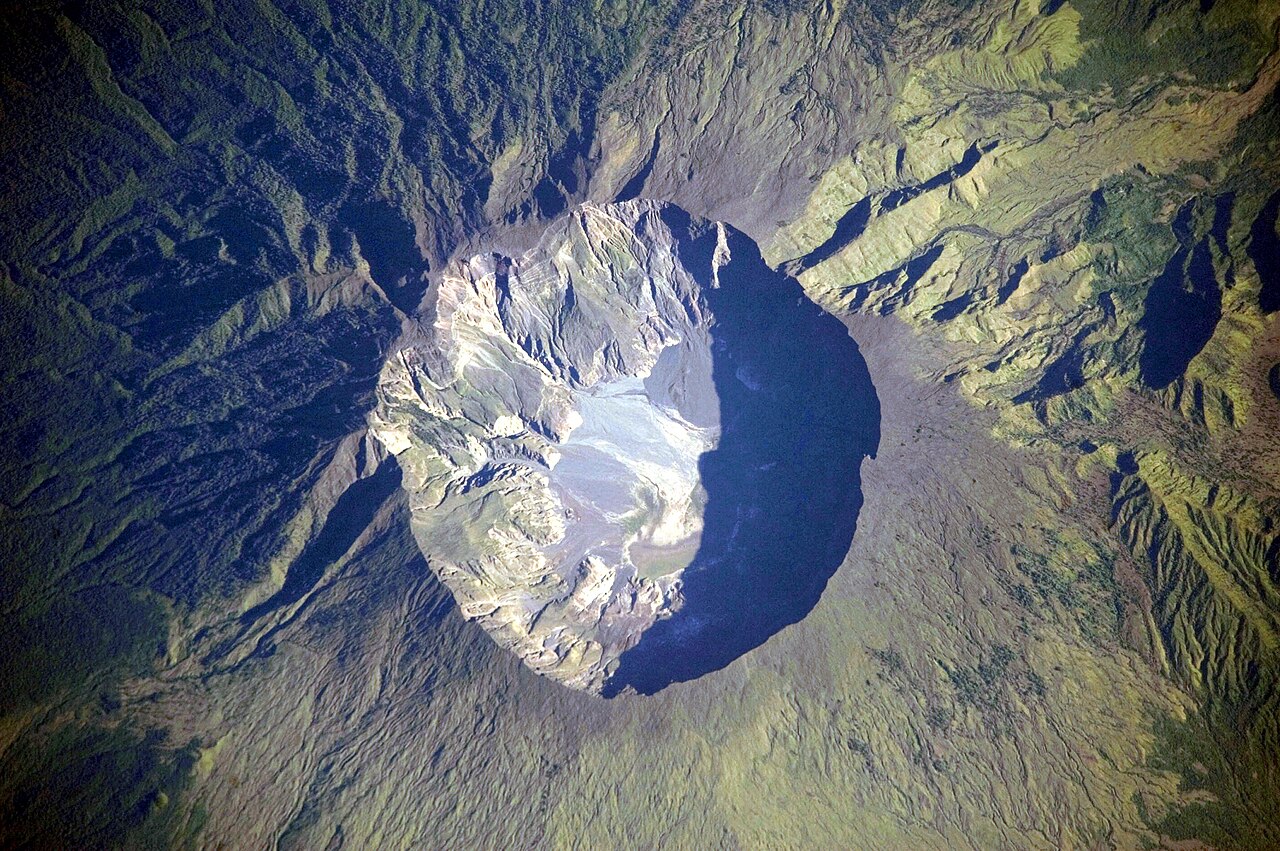
On 5 April 1815, the Tambora volcano, on the island of Sumbawa (in present-day Indonesia), began to rumble. On 10 April, it exploded. The mountain lost more than a thousand metres of height.1
The following year, in 1816, the globe went through what historians call “the year without a summer”: summer frosts, repeated crop failures and local famines.
One detail shows how far the event’s effects reached. That summer, on the shore of Lake Geneva, a small group of English people on holiday found themselves stuck indoors by dreadful weather. To pass the time, they set themselves a challenge: each would write a ghost story.2
That is how a young woman named Mary Shelley came to write Frankenstein.
An Indonesian volcano, an English novel, and between the two a summer that never happened.
The physical mechanism is now thoroughly modelled:
- The explosion hurls immense quantities of sulphur dioxide (SO₂) into the stratosphere.
- These gases turn into sulphuric acid aerosols that remain in suspension for months.
- This veil of aerosols reflects part of the solar radiation back into space, causing a global cooling estimated at between 0.4 °C and 0.7 °C.3
The methodological nuance: Attributing a one-off climatic event or a local famine to a specific eruption requires distinguishing the natural variability of the climate from the direct impact of the volcano. While the causal link between Tambora and the temperature anomaly of 1816 is firmly established, the volcano’s exact share in each regional agricultural crisis continues to be refined by historical and dendrochronological research (the study of tree rings).4
What Pliny saw, and what he did not see
The eruption of Vesuvius in the year 79, which destroyed Pompeii and Herculaneum, is documented by two letters addressed to the historian Tacitus by a direct witness: Pliny the Younger.
These texts are an exceptional historical document, but they must be analysed with critical rigour:
- The time gap: They were written many years after the events.
- The purpose of the account: Pliny seeks above all to immortalise the heroic death of his uncle, Pliny the Elder. It is not a neutral scientific report.
- The point of view: Pliny the Younger observed the phenomenon from Misenum, some twenty kilometres away. He did not directly see the destruction of Pompeii and reports the events in the stricken area on the basis of second-hand accounts.5
The scientific contribution and verification in the field
Pliny nevertheless provides a remarkable description of its shape: he compares the eruption plume to an umbrella pine, made up of a vertical trunk rising very high into the atmosphere before spreading out into a broad crown. This observation is so precise that modern volcanology calls these explosive phenomena with a sustained vertical column “Plinian eruptions”.6
To check an ancient account, one does not try to find out whether the author was sincere. One sets the text against the ground:
- Stratigraphers study the stacking, grain size and composition of the layers of ash and pumice at Pompeii.
- The succession of ejection phases observed in the field matches the sequence described by Pliny: first a long fall of pumice, then nuées ardentes.7
A text on one side, the ground on the other, and the two agree: the whole method rests on this comparison.
The eruption scale (VEI) and its limits
To classify and compare eruptions, the Volcanic Explosivity Index, or VEI, graded from 0 to 8, has been used since 1982.8
What its inventors themselves say about it is worth reporting first, because it is rare and instructive. They explain that the historical records are very incomplete: only the largest eruptions have been well recorded since the early nineteenth century, and many important events went unnoticed before the 1960s. Worse: it will be impossible to fill these gaps after the fact.9
They therefore present their index for what it is: a semi-quantitative compromise between poor data and the need to evaluate the volcanic past nonetheless.10
Here is a tool whose authors announce its weakness from the outset. This approach is exemplary: it is better than a show of precision that could not be sustained.
Three things are worth knowing before using it:
| What you need to know | Why it changes the reading |
|---|---|
| 1. A jump in the scale | The VEI is logarithmic from level 2 upwards: each level represents ten times as much material as the previous one. But between 1 and 2, the jump is a hundredfold, not tenfold. The step is therefore not constant across the whole scale. |
| 2. A composite quantity | The index does not measure a single thing. It combines the volume of material ejected, the height of the plume, and words — from “gentle” to “mega-colossal”. |
| 3. A volume, not a rate | The VEI adds up everything that came out, without looking at how long it took. A slow eruption lasting several months can receive the same figure as an explosion lasting a few hours, even though their effects are completely different. |
Sources for the table11
Finally, it has to be established eruption by eruption: in 2022, the major global database counted nearly 10,000 confirmed eruptions.12
What the exceptions teach: the question of hotspots
The theory of plate tectonics explains the location of the vast majority of volcanoes: they lie at plate boundaries, whether in subduction zones (e.g. the Pacific Ring of Fire) or in accretion zones (e.g. the Mid-Atlantic Ridge).
Yet some volcanoes rise in the very middle of a plate, thousands of kilometres from any boundary — the Hawaiian archipelago, or Réunion. They are called hotspots.
- The dominant explanation: deep mantle plumes, narrow upwellings of very hot material coming from the mantle, sometimes from its boundary with the core, at 2,900 km. The hotspot moves far more slowly than the plate passing over it: this leaves a chain of islands that grow progressively older with distance.
- The debate: there is still discussion about the depth from which these plumes originate and how stationary they really are. The study of these exceptions does not call plate tectonics into question: it clarifies its driving force.13
Note 1
Quantitative analytical methods are used to reconstruct the course of events during and after the cataclysmic eruption of Mount Tambora, Indonesia, on 10 and 11 April 1815.
Stothers, Richard B., “The Great Tambora Eruption in 1815 and Its Aftermath”, Science, vol. 224, 1984, p. 1191-1198
Then, on 5 April 1815, the volcano started erupting. […] On April 10th and 11th, Mt. Tambora literally exploded. […] What was once arguably the highest mountain of the archipelago was now a topless cone. The top third of Mt. Tambora had been blown away.
Brönnimann, Stefan and Krämer, Daniel, Tambora and the “Year Without a Summer” of 1816: A Perspective on Earth and Human Systems Science, Geographica Bernensia G90, Institute of Geography, University of Bern, 2016
Note 2
In the summer of 1816, we visited Switzerland, and became the neighbours of Lord Byron. At first we spent our pleasant hours on the lake, or wandering on its shores; […] But it proved a wet, ungenial summer, and incessant rain often confined us for days to the house. […] "We will each write a ghost story," said Lord Byron; and his proposition was acceded to. […] On the morrow I announced that I had thought of a story. I began that day with the words, It was on a dreary night of November. […] I passed the summer of 1816 in the environs of Geneva.
Shelley, Mary, Frankenstein; or, The Modern Prometheus, édition revue, avec une nouvelle introduction de l’auteur, Henry Colburn et Richard Bentley, Londres, 1831
Note 3
The eruption injected ≈60 mt of sulfur into the stratosphere, six times more than was released by the 1991 Pinatubo eruption. This formed a global sulfate aerosol veil in the stratosphere, which resulted in pronounced climate perturbations. Anomalously cold weather hit the northeastern USA, maritime provinces of Canada, and Europe the following year.
Oppenheimer, Clive, “Climatic, Environmental and Human Consequences of the Largest Known Historic Eruption: Tambora Volcano (Indonesia) 1815”, Progress in Physical Geography, vol. 27, no. 2, 2003, p. 230-259
Note 4
Although many improved drought reconstructions have been published for various regions of the globe in recent years, we do not yet have a complete, global picture of hydro-climate in 1816. […] While there is a direct link from the Tambora eruption to the malnutrition, its role diminishes at each step (i.e., each panel in the figure above). Conversely, at each step, other factors contribute, and in many cases presumably dominate.
Brönnimann, Stefan and Krämer, Daniel, Tambora and the “Year Without a Summer” of 1816: A Perspective on Earth and Human Systems Science, Geographica Bernensia G90, Institute of Geography, University of Bern, 2016
Note 5
Even then, Pliny is writing his letter many years after the events he describes.
Cambridge School Classics Project (University of Cambridge), CSCP Support Materials: Notes and Commentary — Eduqas GCSE Latin, Component 3A, Latin Literature (Narratives): Pliny, The Eruption of Vesuvius, 2020-2021
Note 6
Nubes — incertum procul intuentibus ex quo monte; Vesuvium fuisse postea cognitum est — oriebatur, cuius similitudinem et formam non alia magis arbor quam pinus expresserit. Nam longissimo velut trunco elata in altum quibusdam ramis diffundebatur,
A cloud was rising — those watching from afar could not tell from which mountain; it was later learnt to have been Vesuvius — whose appearance and shape no tree would have expressed better than a pine. For, borne up high as if on a very tall trunk, it spread out into a kind of branches,
Pline le Jeune, Lettres, livre VI, 16 et 20
Note 7
Reinterpretation of the volcanological and historical evidence shows that the eruption of Vesuvius in A.D. 79 consisted of two main phases. The initial 18 to 20-hour Plinian phase caused extensive pumice-fall south of the volcano […] On the second day of activity the Peléan phase occurred, when a series of nuées ardentes or hot ash-avalanches swept down the south and west flanks of the volcano
Sigurdsson, Haraldur, Cashdollar, Stanford and Sparks, R. Stephen J., “The Eruption of Vesuvius in A.D. 79: Reconstruction from Historical and Volcanological Evidence”, American Journal of Archaeology, vol. 86, 1982, p. 39-51
Note 8
A composite estimate of the magnitude of past explosive eruptions, termed the Volcanic Explosivity Index (VEI), is proposed as a semiquantitative compromise between poor data and the need in various disciplines to evaluate the record of past volcanism.
Newhall, Christopher G. and Self, Stephen, “The Volcanic Explosivity Index (VEI): An Estimate of Explosive Magnitude for Historical Volcanism”, Journal of Geophysical Research, vol. 87, C2, 1982, p. 1231-1238
Note 9
Only the largest eruptions have a complete record back to the early 19th Century; other important explosive events went unrecorded prior to about 1960.
Newhall, Christopher G. and Self, Stephen, “The Volcanic Explosivity Index (VEI): An Estimate of Explosive Magnitude for Historical Volcanism”, Journal of Geophysical Research, vol. 87, C2, 1982, p. 1231-1238
so it will be impossible to augment historical records post facto
Newhall, Christopher G. and Self, Stephen, “The Volcanic Explosivity Index (VEI): An Estimate of Explosive Magnitude for Historical Volcanism”, Journal of Geophysical Research, vol. 87, C2, 1982, p. 1231-1238
Note 10
the Volcanic Explosivity Index (VEI), is proposed as a semiquantitative compromise between poor data and the need in various disciplines to evaluate the record of past volcanism
Newhall, Christopher G. and Self, Stephen, “The Volcanic Explosivity Index (VEI): An Estimate of Explosive Magnitude for Historical Volcanism”, Journal of Geophysical Research, vol. 87, C2, 1982, p. 1231-1238
Note 11
Like the earthquake magnitude scale, each VEI scale is 10 times different in terms of ash volume (except for VEI 1, which spans two orders of magnitude, since those eruptions are very small in volume)
Poland, Michael, “The Volcanic Explosivity Index: A tool for comparing the sizes of explosive volcanic eruptions”, Yellowstone Caldera Chronicles, U.S. Geological Survey, Yellowstone Volcano Observatory, sans date, open access
Volume of products, eruption cloud height, and qualitative observations (using terms ranging from "gentle" to "mega-colossal") are used to determine the explosivity value.
U.S. Geological Survey, Volcano Hazards Program, “Volcanic Explosivity Index (VEI) is a numeric scale that measures t...” (titre tronqué sur le site), page d’image avec description détaillée, sans date, open access
there are no consistent instrumental means of determining an eruption size in the same way that earthquake magnitudes are calculated […] Newhall and Self decided that it would be best to utilize numerous different datasets
United States Geological Survey, Yellowstone Volcano Observatory, “The Volcanic Explosivity Index: A Tool for Comparing the Sizes of Explosive Volcanic Eruptions”
Note 12
As of this update we list 1,337 volcanoes thought to have erupted or been otherwise volcanically active during the Holocene, and 1,324 on the Pleistocene list; confirmed eruptions total 9,874.
Global Volcanism Program, Smithsonian Institution, “Volcanoes of the World (VOTW) Database Information”, base de données Volcanoes of the World, v. 5.4.0, 7 August 2026, open access
Note 13
Almost a decade later, in 1971, it was hypothesized that such a hotspot could form above a vertical, narrow, hot mantle plume rising from the deep mantle […].
Koppers, Anthony A. P., Becker, Thorsten W., Jackson, Matthew G. et al., “Mantle Plumes and Their Role in Earth Processes”, Nature Reviews Earth & Environment, vol. 2, 2021, p. 382-401
If there are convection currents in the Pacific region and if the upper parts of these cells move faster than the central parts, sources of lava within the slower moving cores could give rise to linear chains of progressively older volcanic piles such as the Hawaiian Islands.
Wilson, J. Tuzo, “A Possible Origin of the Hawaiian Islands”, Canadian Journal of Physics, vol. 41, 1963, p. 863-870
The origin of mantle hotspots is a controversial topic. Only seven (‘primary’) out of 49 hotspots meet criteria aimed at detecting a very deep origin (three in the Pacific, four in the Indo-Atlantic hemisphere). In each hemisphere these move slowly, whereas there has been up to 50 mm/a motion between the two hemispheres prior to 50 Ma ago.
Courtillot, Vincent et al., “Three Distinct Types of Hotspots in the Earth’s Mantle”, Earth and Planetary Science Letters, vol. 205, 2003, p. 295-308
Almost a decade later, in 1971, it was hypothesized that such a hotspot could form above a vertical, narrow, hot mantle plume rising from the deep mantle […]. To date, it is understood that mantle plumes could start as deep as the core–mantle boundary at roughly 2,900-km depth […].
Koppers, Anthony A. P., Becker, Thorsten W., Jackson, Matthew G. et al., “Mantle Plumes and Their Role in Earth Processes”, Nature Reviews Earth & Environment, vol. 2, 2021, p. 382-401
Notes and sources
- ↑
Passage the Tambora volcano, […] (in present-day Indonesia), […] On 10 April, it exploded.
Quantitative analytical methods are used to reconstruct the course of events during and after the cataclysmic eruption of Mount Tambora, Indonesia, on 10 and 11 April 1815.
Source Stothers, Richard B., “The Great Tambora Eruption in 1815 and Its Aftermath”, Science, vol. 224, 1984, p. 1191-1198, abstract.
Paywalled · checked on 9 September 2026
Passage On 5 April 1815, the Tambora volcano […] began to rumble. On 10 April, it exploded. The mountain lost more than a thousand metres of height.
Then, on 5 April 1815, the volcano started erupting. […] On April 10th and 11th, Mt. Tambora literally exploded. […] What was once arguably the highest mountain of the archipelago was now a topless cone. The top third of Mt. Tambora had been blown away.
Source Brönnimann, Stefan and Krämer, Daniel, Tambora and the “Year Without a Summer” of 1816: A Perspective on Earth and Human Systems Science, Geographica Bernensia G90, Institute of Geography, University of Bern, 2016, p. 8-9, section “The Eruption” (the table “The 1815 Tambora eruption in numbers”, p. 8, also gives “Altitude before eruption ca. 4300 m” and “Present Altitude 2850 m”).
Open access open the source · checked on 27 October 2026
- ↑
Passage That summer, on the shore of Lake Geneva, a small group of English people on holiday found themselves stuck indoors by dreadful weather […] That is how a young woman named Mary Shelley came to write Frankenstein.
In the summer of 1816, we visited Switzerland, and became the neighbours of Lord Byron. At first we spent our pleasant hours on the lake, or wandering on its shores; […] But it proved a wet, ungenial summer, and incessant rain often confined us for days to the house. […] "We will each write a ghost story," said Lord Byron; and his proposition was acceded to. […] On the morrow I announced that I had thought of a story. I began that day with the words, It was on a dreary night of November. […] I passed the summer of 1816 in the environs of Geneva.
Source Shelley, Mary, Frankenstein; or, The Modern Prometheus, édition revue, avec une nouvelle introduction de l’auteur, Henry Colburn et Richard Bentley, Londres, 1831, author’s introduction (1831); preface (dated Marlow, September 1817).
Public domain open the source · checked on 9 September 2026
- ↑
Passage The explosion hurls immense quantities of sulphur dioxide […] into the stratosphere. […] These gases turn into sulphuric acid aerosols
The eruption injected ≈60 mt of sulfur into the stratosphere, six times more than was released by the 1991 Pinatubo eruption. This formed a global sulfate aerosol veil in the stratosphere, which resulted in pronounced climate perturbations. Anomalously cold weather hit the northeastern USA, maritime provinces of Canada, and Europe the following year.
Source Oppenheimer, Clive, “Climatic, Environmental and Human Consequences of the Largest Known Historic Eruption: Tambora Volcano (Indonesia) 1815”, Progress in Physical Geography, vol. 27, no. 2, 2003, p. 230-259, abstract.
Paywalled · checked on 9 September 2026
- ↑
Passage the volcano’s exact share in each regional agricultural crisis continues to be refined
Although many improved drought reconstructions have been published for various regions of the globe in recent years, we do not yet have a complete, global picture of hydro-climate in 1816. […] While there is a direct link from the Tambora eruption to the malnutrition, its role diminishes at each step (i.e., each panel in the figure above). Conversely, at each step, other factors contribute, and in many cases presumably dominate.
Source Brönnimann, Stefan and Krämer, Daniel, Tambora and the “Year Without a Summer” of 1816: A Perspective on Earth and Human Systems Science, Geographica Bernensia G90, Institute of Geography, University of Bern, 2016, p. 17, box “Dry in the monsoon regions” (section “Climate Anomalies in Proxies”); p. 30, box “A Climate – Society Interaction Model”.
Open access open the source · checked on 27 October 2026
- ↑
Passage They were written many years after the events.
Even then, Pliny is writing his letter many years after the events he describes.
Source Cambridge School Classics Project (University of Cambridge), CSCP Support Materials: Notes and Commentary — Eduqas GCSE Latin, Component 3A, Latin Literature (Narratives): Pliny, The Eruption of Vesuvius, 2020-2021, p. 8, notes on section A.
Open access open the source · checked on 25 October 2026
- ↑
Passage he compares the eruption plume to an umbrella pine
Nubes — incertum procul intuentibus ex quo monte; Vesuvium fuisse postea cognitum est — oriebatur, cuius similitudinem et formam non alia magis arbor quam pinus expresserit. Nam longissimo velut trunco elata in altum quibusdam ramis diffundebatur,
Editors’ translation A cloud was rising — those watching from afar could not tell from which mountain; it was later learnt to have been Vesuvius — whose appearance and shape no tree would have expressed better than a pine. For, borne up high as if on a very tall trunk, it spread out into a kind of branches,
Source Pline le Jeune, Lettres, livre VI, 16 et 20, book VI, letter 16 (to Tacitus), § 5-6.
Public domain open the source · checked on 24 October 2026
- ↑
Passage The succession of ejection phases observed in the field matches the sequence described by Pliny
Reinterpretation of the volcanological and historical evidence shows that the eruption of Vesuvius in A.D. 79 consisted of two main phases. The initial 18 to 20-hour Plinian phase caused extensive pumice-fall south of the volcano […] On the second day of activity the Peléan phase occurred, when a series of nuées ardentes or hot ash-avalanches swept down the south and west flanks of the volcano
Source Sigurdsson, Haraldur, Cashdollar, Stanford and Sparks, R. Stephen J., “The Eruption of Vesuvius in A.D. 79: Reconstruction from Historical and Volcanological Evidence”, American Journal of Archaeology, vol. 86, 1982, p. 39-51, abstract.
Paywalled · checked on 9 September 2026
- ↑
Passage the Volcanic Explosivity Index, or VEI, graded from 0 to 8, has been used since 1982
A composite estimate of the magnitude of past explosive eruptions, termed the Volcanic Explosivity Index (VEI), is proposed as a semiquantitative compromise between poor data and the need in various disciplines to evaluate the record of past volcanism.
Source Newhall, Christopher G. and Self, Stephen, “The Volcanic Explosivity Index (VEI): An Estimate of Explosive Magnitude for Historical Volcanism”, Journal of Geophysical Research, vol. 87, C2, 1982, p. 1231-1238, abstract.
Paywalled open the source · checked on 9 September 2026
- ↑
Passage only the largest eruptions have been well recorded since the early nineteenth century, and many important events went unnoticed before the 1960s
Only the largest eruptions have a complete record back to the early 19th Century; other important explosive events went unrecorded prior to about 1960.
Source Newhall, Christopher G. and Self, Stephen, “The Volcanic Explosivity Index (VEI): An Estimate of Explosive Magnitude for Historical Volcanism”, Journal of Geophysical Research, vol. 87, C2, 1982, p. 1231-1238, abstract.
Paywalled open the source · checked on 9 September 2026
Passage it will be impossible to fill these gaps after the fact
so it will be impossible to augment historical records post facto
Source Newhall, Christopher G. and Self, Stephen, “The Volcanic Explosivity Index (VEI): An Estimate of Explosive Magnitude for Historical Volcanism”, Journal of Geophysical Research, vol. 87, C2, 1982, p. 1231-1238, abstract.
Paywalled open the source · checked on 9 September 2026
- ↑
Passage a semi-quantitative compromise between poor data and the need to evaluate the volcanic past nonetheless
the Volcanic Explosivity Index (VEI), is proposed as a semiquantitative compromise between poor data and the need in various disciplines to evaluate the record of past volcanism
Source Newhall, Christopher G. and Self, Stephen, “The Volcanic Explosivity Index (VEI): An Estimate of Explosive Magnitude for Historical Volcanism”, Journal of Geophysical Research, vol. 87, C2, 1982, p. 1231-1238, abstract.
Paywalled open the source · checked on 9 September 2026
- ↑
Passage The VEI is logarithmic from level 2 upwards […] But between 1 and 2, the jump is a hundredfold, not tenfold.
Like the earthquake magnitude scale, each VEI scale is 10 times different in terms of ash volume (except for VEI 1, which spans two orders of magnitude, since those eruptions are very small in volume)
Source Poland, Michael, “The Volcanic Explosivity Index: A tool for comparing the sizes of explosive volcanic eruptions”, Yellowstone Caldera Chronicles, U.S. Geological Survey, Yellowstone Volcano Observatory, sans date, open access, article, paragraph on ash volume as the main criterion.
Open access open the source · checked on 24 October 2026
Passage It combines the volume of material ejected, the height of the plume, and words — from “gentle” to “mega-colossal”.
Volume of products, eruption cloud height, and qualitative observations (using terms ranging from "gentle" to "mega-colossal") are used to determine the explosivity value.
Source U.S. Geological Survey, Volcano Hazards Program, “Volcanic Explosivity Index (VEI) is a numeric scale that measures t...” (titre tronqué sur le site), page d’image avec description détaillée, sans date, open access, “Detailed Description” section below the image.
Open access open the source · checked on 24 October 2026
Passage why there is no single instrument for measuring an eruption, and the choice to cross-check several datasets
there are no consistent instrumental means of determining an eruption size in the same way that earthquake magnitudes are calculated […] Newhall and Self decided that it would be best to utilize numerous different datasets
Source United States Geological Survey, Yellowstone Volcano Observatory, “The Volcanic Explosivity Index: A Tool for Comparing the Sizes of Explosive Volcanic Eruptions”, observatory article.
Open access open the source · checked on 9 September 2026
- ↑
Passage in 2022, the major global database counted nearly 10,000 confirmed eruptions
As of this update we list 1,337 volcanoes thought to have erupted or been otherwise volcanically active during the Holocene, and 1,324 on the Pleistocene list; confirmed eruptions total 9,874.
Source Global Volcanism Program, Smithsonian Institution, “Volcanoes of the World (VOTW) Database Information”, base de données Volcanoes of the World, v. 5.4.0, 7 August 2026, open access, table of versions, entry v. 4.11.0 (8 June 2022).
Open access open the source · checked on 24 October 2026
- ↑
Passage deep mantle plumes, narrow upwellings of very hot material coming from the mantle
Almost a decade later, in 1971, it was hypothesized that such a hotspot could form above a vertical, narrow, hot mantle plume rising from the deep mantle […].
Source Koppers, Anthony A. P., Becker, Thorsten W., Jackson, Matthew G. et al., “Mantle Plumes and Their Role in Earth Processes”, Nature Reviews Earth & Environment, vol. 2, 2021, p. 382-401, accepted manuscript, introduction, 1st paragraph (p. 1).
Paywalled; accepted manuscript open access open the source · checked on 27 October 2026
Passage The hotspot moves far more slowly than the plate passing over it: this leaves a chain of islands that grow progressively older
If there are convection currents in the Pacific region and if the upper parts of these cells move faster than the central parts, sources of lava within the slower moving cores could give rise to linear chains of progressively older volcanic piles such as the Hawaiian Islands.
Source Wilson, J. Tuzo, “A Possible Origin of the Hawaiian Islands”, Canadian Journal of Physics, vol. 41, 1963, p. 863-870, abstract, second paragraph.
Paywalled · checked on 25 October 2026
Passage there is still discussion about the depth from which these plumes originate and how stationary they really are
The origin of mantle hotspots is a controversial topic. Only seven (‘primary’) out of 49 hotspots meet criteria aimed at detecting a very deep origin (three in the Pacific, four in the Indo-Atlantic hemisphere). In each hemisphere these move slowly, whereas there has been up to 50 mm/a motion between the two hemispheres prior to 50 Ma ago.
Source Courtillot, Vincent et al., “Three Distinct Types of Hotspots in the Earth’s Mantle”, Earth and Planetary Science Letters, vol. 205, 2003, p. 295-308, abstract.
Paywalled · checked on 25 October 2026
Passage deep mantle plumes, narrow upwellings of very hot material coming from the mantle, sometimes from its boundary with the core, at 2,900 km
Almost a decade later, in 1971, it was hypothesized that such a hotspot could form above a vertical, narrow, hot mantle plume rising from the deep mantle […]. To date, it is understood that mantle plumes could start as deep as the core–mantle boundary at roughly 2,900-km depth […].
Source Koppers, Anthony A. P., Becker, Thorsten W., Jackson, Matthew G. et al., “Mantle Plumes and Their Role in Earth Processes”, Nature Reviews Earth & Environment, vol. 2, 2021, p. 382-401, accepted manuscript, introduction, 1st paragraph (4th sentence) and start of the 2nd (p. 1).
Paywalled; accepted manuscript open access open the source · checked on 27 October 2026
Bibliography
16
- Brönnimann, Stefan and Krämer, Daniel, Tambora and the “Year Without a Summer” of 1816: A Perspective on Earth and Human Systems Science, Geographica Bernensia G90, Institute of Geography, University of Bern, 2016, open access (the eruption began on 5 April 1815, exploded on 10 and 11 April, and the top third of the mountain was lost: about 4,300 m before, 2,850 m today). https://doi.org/10.4480/GB2016.G90.01
- Cambridge School Classics Project (University of Cambridge), CSCP Support Materials: Notes and Commentary — Eduqas GCSE Latin, Component 3A, Latin Literature (Narratives): Pliny, The Eruption of Vesuvius, 2020-2021, open access (Pliny did not see what his uncle did after leaving Misenum, and he wrote his letter many years after the events, p. 8; accessed 25 October 2026). https://www.exams.cambridgescp.com/sites/www.cambridgescp.com/files/2020-2021_pliny_vesuvius_notes_and_commentary_fv1.pdf
- Courtillot, Vincent et al., “Three Distinct Types of Hotspots in the Earth’s Mantle”, Earth and Planetary Science Letters, vol. 205, 2003, p. 295-308, paywalled (the debate on the depth and stationarity of the plumes).
- Global Volcanism Program, Smithsonian Institution, “Volcanoes of the World (VOTW) Database Information”, base de données Volcanoes of the World, v. 5.4.0, 7 August 2026, open access (nearly 10,000 confirmed eruptions in the database: 9,874 at the v. 4.11.0 update of 8 June 2022; accessed 24 October 2026). https://volcano.si.edu/gvp_votw.cfm
- Koppers, Anthony A. P., Becker, Thorsten W., Jackson, Matthew G. et al., “Mantle Plumes and Their Role in Earth Processes”, Nature Reviews Earth & Environment, vol. 2, 2021, p. 382-401, paywalled; accepted manuscript open access (the 1971 hypothesis of a narrow, hot plume rising from the deep mantle; plumes that may originate at the core–mantle boundary, at about 2,900 km). https://doi.org/10.1038/s43017-021-00168-6 ; accepted manuscript: https://par.nsf.gov/servlets/purl/10319063
- Morgan, W. Jason, “Convection Plumes in the Lower Mantle”, Nature, vol. 230, 1971, p. 42-43, paywalled (the mantle plume hypothesis).
- Newhall, Christopher G. and Self, Stephen, “The Volcanic Explosivity Index (VEI): An Estimate of Explosive Magnitude for Historical Volcanism”, Journal of Geophysical Research, vol. 87, C2, 1982, p. 1231-1238, paywalled (the incompleteness of the records and the impossibility of filling the gaps after the fact; the index presented as a semi-quantitative compromise; volume, plume height and qualitative descriptors). https://doi.org/10.1029/JC087iC02p01231
- Oppenheimer, Clive, “Climatic, Environmental and Human Consequences of the Largest Known Historic Eruption: Tambora Volcano (Indonesia) 1815”, Progress in Physical Geography, vol. 27, no. 2, 2003, p. 230-259, paywalled (the physical mechanism, the estimated cooling, the limits of regional attribution).
- Pline le Jeune, Lettres, livre VI, 16 et 20, public domain (the account of the eruption; the comparison with an umbrella pine).
- Poland, Michael, “The Volcanic Explosivity Index: A tool for comparing the sizes of explosive volcanic eruptions”, Yellowstone Caldera Chronicles, U.S. Geological Survey, Yellowstone Volcano Observatory, sans date, open access (each VEI level is worth ten times more ash, except level 1, which spans two orders of magnitude). https://usgs.gov/observatories/yvo/news/volcanic-explosivity-index-a-tool-comparing-sizes-explosive-volcanic
- Shelley, Mary, Frankenstein; or, The Modern Prometheus, édition revue, avec une nouvelle introduction de l’auteur, Henry Colburn et Richard Bentley, Londres, 1831, public domain (the summer of 1816 in Switzerland, by the lake, spoilt by rain; the challenge for each to write a ghost story; the birth of Frankenstein). https://gutenberg.org/cache/epub/42324/pg42324-images.html
- Sigurdsson, Haraldur, Cashdollar, Stanford and Sparks, R. Stephen J., “The Eruption of Vesuvius in A.D. 79: Reconstruction from Historical and Volcanological Evidence”, American Journal of Archaeology, vol. 86, 1982, p. 39-51, paywalled (the cross-check between Pliny’s text and the stratigraphy in the field).
- Stothers, Richard B., “The Great Tambora Eruption in 1815 and Its Aftermath”, Science, vol. 224, 1984, p. 1191-1198, paywalled (the eruption and the year without a summer).
- U.S. Geological Survey, Volcano Hazards Program, “Volcanic Explosivity Index (VEI) is a numeric scale that measures t...” (titre tronqué sur le site), page d’image avec description détaillée, sans date, open access (volume, cloud height and qualitative observations ranging from “gentle” to “mega-colossal”). https://www.usgs.gov/media/images/volcanic-explosivity-index-vei-a-numeric-scale-measures-t
- United States Geological Survey, Yellowstone Volcano Observatory, “The Volcanic Explosivity Index: A Tool for Comparing the Sizes of Explosive Volcanic Eruptions”, open access (why there is no single instrument for measuring an eruption, and the choice to cross-check several datasets). https://www.usgs.gov/observatories/yvo/news/volcanic-explosivity-index-a-tool-comparing-sizes-explosive-volcanic
- Wilson, J. Tuzo, “A Possible Origin of the Hawaiian Islands”, Canadian Journal of Physics, vol. 41, 1963, p. 863-870, paywalled (the idea of a lava source moving more slowly than the surface passing over it).
Spotted an error or have a doubt? Write to us.